Severe Storm Alert: What You Need to Know for Friday in the Tri-State Area
Quick Summary: The Big Picture
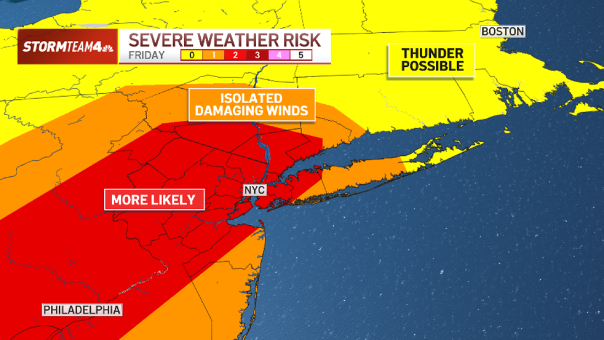
Think of this like a "Yellow Light" for weather. A Level 2 out of 5 risk means be prepared, but don’t panic. The main concern is strong, damaging winds (60+ mph), not tornadoes or giant hail. Storms will likely pop up during the hottest part of the day and peak around dinnertime.
Where Is the Threat?
The Level 2 (Slight Risk) zone covers a huge area:
- New York City (all 5 boroughs)
- Lower Hudson Valley
- North & Central New Jersey
- Extends all the way down to Washington, D.C.
IMPORTANT: A Severe Thunderstorm Watch is active until 9 PM Friday for all these areas. A "Watch" means conditions are right for bad storms—stay alert!
What Kind of Weather Are We Talking About?
| Threat |
Likelihood |
What It Means for You |
| Damaging Straight-Line Winds |
HIGH (Main Threat) |
Winds 60+ mph. Can knock down trees, power lines, and damage roofs. This is the #1 danger. |
| Flash Flooding |
LOW to MODERATE |
Heavy rain could cause quick flooding in poor drainage areas. Most spots get < 1 inch, but a few unlucky spots could see 2–4+ inches fast. |
| Tornadoes |
VERY LOW (Unlikely) |
Not zero, but very close to it. |
| Large Hail |
VERY LOW (Unlikely) |
Not expected to be a significant issue. |
ELI5: What are "Straight-Line Winds"?
Imagine a giant, invisible hair dryer blasting down from a storm cloud. When that air hits the ground, it spreads out in straight lines at 60+ mph. It causes the same damage as a weak tornado but without the spinning.
Timeline: When Will It Happen?
| Time |
What to Expect |
| Mid-Afternoon (1–3 PM) |
First storms bubble up. It’s hot (~90°F), giving storms fuel. Isolated at first—hit or miss. |
| Early Evening (4–7 PM) |
Prime Time. Storms become more numerous and stronger. Peak wind & flood risk. |
| Mid-Evening (7–9 PM) |
Still active. Watch still in effect. Slowly winding down. |
| After 9 PM |
Rapid weakening. Storms become isolated and much weaker. Watch expires. |
Rainfall: How Much & How Fast?
- Most areas: Less than 1 inch. Manageable.
- Isolated "Bullseyes": 2 to 4+ inches in a very short time.
- Good News: Storms are moving along (not training/stalling over the same spot). This keeps totals mostly in check.
- Bad News: The air is juiced with moisture (like a soaked sponge). The strongest storms will wring it out fast.
The Weekend Outlook: Much Better!
| Day |
Forecast |
| Saturday |
Lower chance of a few afternoon/evening showers/storms. Not a washout. |
| Sunday |
Fantastic. Rain chances near zero for NYC. Perfect recovery day! |
Your 5-Step "Stay Safe" Plan
- Charge Everything NOW. Phones, power banks, laptops. Power outages are the #1 result of 60 mph winds.
- Secure the Outdoors. Bring in or tie down patio furniture, grills, trampolines, garbage cans, umbrellas. They become missiles in 60 mph winds.
- Park Smart. If you have a garage, use it. If not, avoid parking under large trees or power lines.
- Enable Alerts. Make sure Wireless Emergency Alerts (WEA) are ON in your phone settings (usually under Notifications -> Emergency Alerts). This is your lifeline for Warnings (which mean it’s happening now).
- Plan Your Commute. If possible, be off the roads by early evening (4–5 PM). Driving in 60 mph gusts and sudden downpours is dangerous. If caught driving: Pull over safely, stay in the car, avoid trees/power lines.
Hour-by-Hour Radar Snapshots (What the Models Show)
The images below represent model projections of storm coverage at specific times. They show the general trend: isolated start → widespread peak → evening decay.
Note: These are simulations, not exact predictions. Use them to see the trend, not the exact street-level location.
- Early Afternoon: Isolated cells popping.
- Mid-Afternoon: Coverage increasing.
- Late Afternoon: More numerous storms.
- Early Evening (Peak): Widespread activity, strongest storms.
- Dinnertime: Peak coverage continuing.
- Late Evening: Rapid weakening begins.
- Post 9 PM: Isolated, weakening remnants.
Summary Checklist
- [ ] Threat Level: Level 2/5 (Slight Risk) – Be Prepared.
- [ ] Main Hazard: 60+ mph Straight-Line Winds (Tree/power line damage, power outages).
- [ ] Secondary Hazard: Localized Flash Flooding (Isolated 2–4" rain possible).
- [ ] Non-Threats: Tornadoes & Large Hail very unlikely.
- [ ] Timing: Mid-afternoon start → Peak 4–9 PM → Done by 10 PM.
- [ ] Watch Active: Until 9 PM Friday.
- [ ] Weekend: Saturday = Low storm chance. Sunday = Beautiful.
FAQ: Your Questions Answered
1. "Level 2 out of 5 doesn’t sound bad. Why the fuss?"
Because Level 2 is the most common level for actual damaging wind events in our area. Level 3+ is rare here. Level 2 means "Expect some storms to be severe." With winds of 60+ mph, "some" is enough to cause widespread power outages and tree damage.
2. "What’s the difference between a Watch and a Warning?"
- WATCH (Current): "Ingredients are ready. Be prepared." Covers a large area for hours.
- WARNING (Imminent/Occurring): "It’s happening NOW near you. Take action immediately." Covers a small polygon (like a county or part of one) for 30–60 mins. This is when you go inside, away from windows.
3. "Should I cancel my outdoor plans for Friday evening?"
Yes, strongly consider it. The peak threat (4–9 PM) overlaps exactly with dinner/sports/commute time. If you must be out, have a solid Plan B (sturdy building nearby) and watch radar/alerts constantly.
4. "My area got missed by storms last time. Will it happen again?"
Don’t bet on it. "Hit or miss" applies to which specific towns get the worst wind cores. The coverage of storms will be high this evening. Prepare as if you are the target.
5. "What if a Severe Thunderstorm Warning is issued for my town right now?"
- Go inside a sturdy building immediately. (Not a shed, not a carport).
- Stay away from windows. (Wind can blow debris through glass).
- Get to the lowest floor, interior room. (Same as tornado safety, minus the helmet requirement).
- Wait 15–30 mins after the storm passes. Dangerous winds can come in bursts.
Stay Weather Aware, Stay Safe!
Keep an eye on the sky and your phone alerts this afternoon and evening. The weekend looks great!
 1
1