Surging Humidity Unleashes Torrential Downpours Late Week
WDBJ7 Weather Forecast: Storms, Flood Risk, Then Beautiful Weekend Ahead
ELI5 Summary: We’re starting with foggy mornings, then get hit with two days of storms (Thursday-Friday) that could cause flooding. But don’t worry! The weekend brings sunshine, lower humidity, and much cooler temperatures—like a weather "reset button."
This Morning: Foggy Start
What’s happening right now:
- Temperatures in the 70s — mild but muggy (sticky humid)
- Patchy fog reducing visibility for morning commute
- Otherwise calm conditions
IMPORTANT: DRIVING SAFETY
Patchy fog = slower commute.
- Leave extra space between cars
- Use low-beam headlights (not high beams!)
- Give yourself extra time to get where you’re going
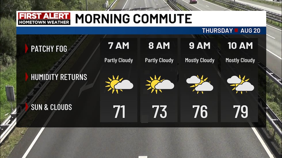
Calm conditions, with some patchy fog (WDBJ7)
Thursday: Storms Return
The setup: A cold front (boundary where cooler air pushes out warmer air) is approaching, and humidity is climbing.
What to expect:
- Showers and thunderstorms developing by afternoon
- Heavy downpours — rain coming down fast
- Gusty winds possible with stronger storms
- High temperatures: well into the 80s, some spots touching low 90s
WHAT IS A COLD FRONT?
Think of it like a snowplow pushing warm, moist air upward. As that air rises, it cools and forms clouds → rain → storms. Behind the front = cooler, drier air.
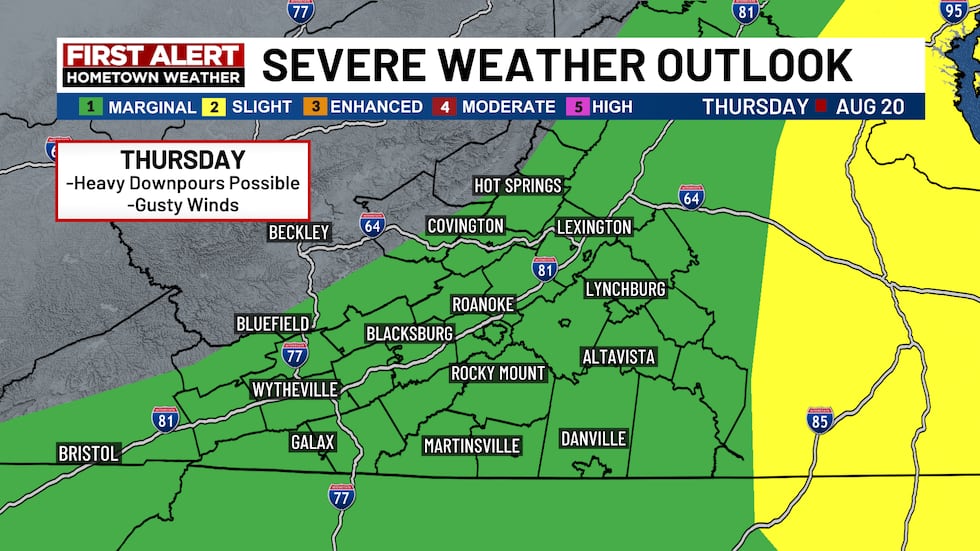
Heavy downpours and gusty winds possible today (WDBJ7)
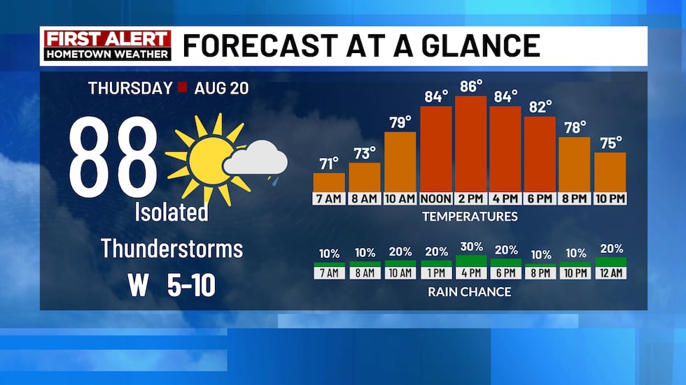
Highs sit well into the 80s (WDBJ7)
Friday: Flood Risk Day
The concern: Slow-moving downpours = rain stays over same area longer = water piles up.
Key details:
- More showers and downpours throughout the day
- Heightened flood potential in some communities
- Main concern areas: Piedmont and eastern Southside regions
- Highs slightly cooler: low to mid 80s
IMPORTANT: FLOOD SAFETY REMINDERS
- Never drive through flooded roads — 6 inches of moving water can knock you down, 12 inches can float a car
- "Turn around, don’t drown" — it’s not just a saying, it saves lives
- Keep an eye on local alerts if you live in flood-prone areas
- Have multiple ways to get warnings (phone alerts, weather radio, local news)
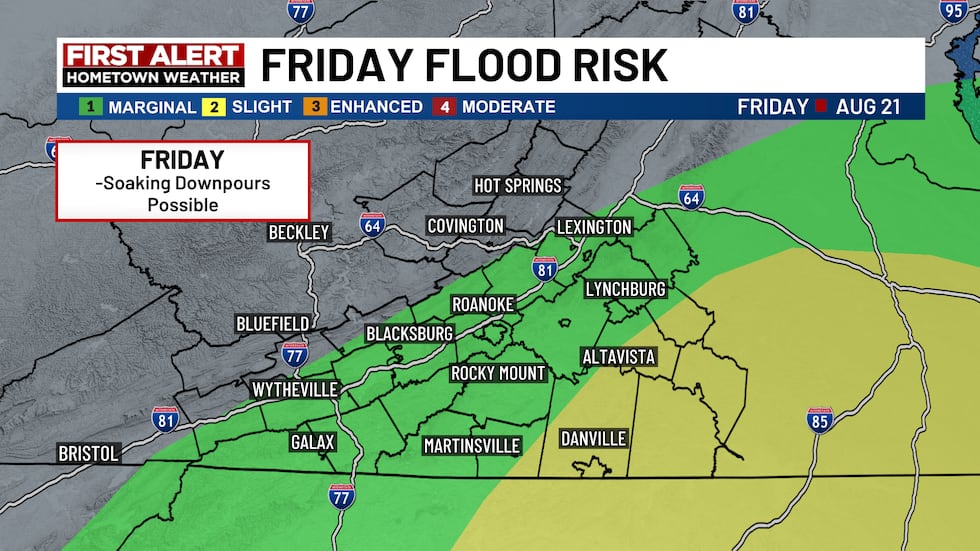
Slow moving downpours could lead to localized flooding concerns on Friday, mainly over the piedmont and eastern southside (WDBJ)
Weekend & Next Week: The "Reward" Weather
Good news! After the storms, a dip in the jet stream brings refreshing changes.
WHAT’S THE JET STREAM?
A fast-moving "river of air" high up in the atmosphere that steers weather systems. When it dips south, it brings cooler air from the north. Think of it like a curtain rod — where it hangs determines who gets cool air and who stays warm.
What’s coming:
- Sunshine returns Sunday
- Much lower humidity — air feels comfortable, not sticky
- Below-average high temperatures — cooler than normal for this time of year
- Overnight lows possibly in the 50s — jacket weather in the mornings!
- Pleasant conditions continuing into early next week
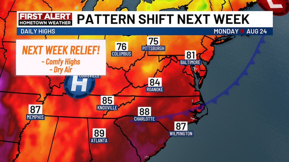
Less humid later this weekend into early next week (WDBJ)
Drought Monitor Update (August 13): Improving!
The big picture: Rain has helped, but we’re not out of the woods yet.
Current status:
- Extreme drought: Mostly gone from the area
- Severe drought: Still covers eastern half of the region
- Moderate & "Abnormally Dry" conditions: Expanding eastward in Virginia
- Bottom line: We still need more rain!
DROUGHT CATEGORIES EXPLAINED (SIMPLE VERSION)
- Abnormally Dry: "Things are getting dry, keep an eye on it"
- Moderate Drought: "Crops/grass stressed, water levels dropping"
- Severe Drought: "Significant crop losses, water restrictions likely"
- Extreme Drought: "Major crop/pasture losses, widespread water shortages"
- Exceptional Drought: "Exceptional and widespread crop/pasture losses, water emergencies"
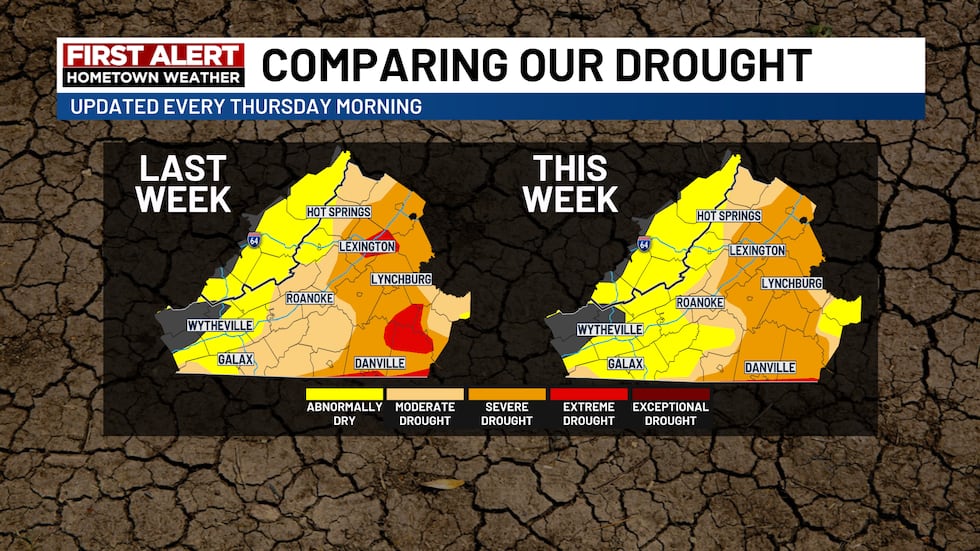
The drought monitor continues to improve (WDBJ7)
Tracking the Tropics: Quiet for Now
- Atlantic Basin: Extremely quiet
- Expected to stay quiet this week
- Reason: Strengthening El Niño
WHAT IS EL NIÑO?
A natural climate pattern where Pacific Ocean waters near the equator get warmer than usual. This changes wind patterns worldwide — including creating stronger wind shear (changing winds with height) over the Atlantic, which tears apart developing hurricanes. Think of it as nature’s hurricane shield.
Watch WDBJ7 Live!
First Alert Hometown Weather Show
- When: 1:30 PM, Monday through Friday
- Where: www.wdbj7.com/livestream/
- Why watch: Exclusive weather content you won’t see anywhere else!
Quick-Look: 5-Day Planner
| Day | Conditions | High Temp | Key Concern |
|---|---|---|---|
| Today | AM fog, then storms PM | 80s–low 90s | Gusty winds, heavy rain |
| Friday | Showers & downpours | Low-mid 80s | FLOOD RISK |
| Saturday | Improving | 80s | Lingering shower chance |
| Sunday | Sunshine! | 70s–low 80s | Beautiful day |
| Monday | Sunny, cool | 70s | Overnight lows in 50s! |
Summary
- This Morning: Drive carefully in patchy fog
- Thursday: Afternoon storms with heavy rain & gusty winds
- Friday: Highest impact day — slow storms = flood risk, especially Piedmont/eastern Southside
- Weekend: Fantastic! Sunny, low humidity, cooler — possibly 50s at night
- Drought: Improving but severe drought persists east; more rain needed
- Tropics: Quiet thanks to El Niño
FAQ
1. When exactly will the storms hit Thursday?
Storms are expected to develop by the afternoon. Morning should be dry, but keep an eye on the radar after lunchtime.
2. How bad could Friday’s flooding get?
The risk is localized — not everywhere will flood. But where slow-moving storms park themselves, flash flooding is possible. The Piedmont and eastern Southside have the highest concern.
3. Will the weekend really be that nice?
Yes! The jet stream dip is a strong signal for a pattern change. Highs in the 70s/low 80s with low humidity and 50s overnight is about as good as it gets in mid-August.
4. Does the drought improvement mean water restrictions will end?
That’s up to local water authorities. The extreme drought designation is mostly gone, which is huge progress, but severe drought remains in eastern areas. Restrictions may ease in some places but continue in others.
5. What does "strengthening El Niño" mean for the rest of hurricane season?
Typically, El Niño suppresses Atlantic hurricane activity. But "quiet this week" doesn’t mean "quiet all season." Always stay prepared through November 30th!
Copyright 2025 WDBJ. All rights reserved.