Popular Posts

Dangerous Tornado & Storm Warnings Hit Ocean, Burlington—Are You Ready?

Dangerous Tornado & Storm Warnings Hit Ocean, Burlington—Are You Ready?

Tornado and Severe Thunderstorm Warnings Issued for South Jersey Area

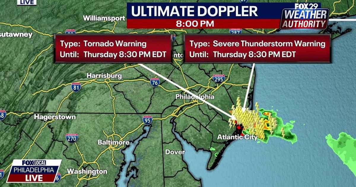
A news report from FOX (station WTXF in Philadelphia) shared that the National Weather Service in Mount Holly issued weather warnings for parts of New Jersey. Meteorologist Scott Williams explained the severe weather happening in southern New Jersey in a video report.

What Happened: The Big Warning

The National Weather Service in Mount Holly issued a tornado warning (this means a tornado may happen soon) for:

  • South central Ocean County
  • Southeastern Burlington County in New Jersey

This warning was in effect until 8:30 p.m. on Thursday, July 16.

8:02 p.m. – Severe Thunderstorm Capable of Producing Tornado

What We Know

Here is the simple breakdown of what was happening:

  • At 8:02 p.m., a severe thunderstorm with radar-indicated rotation (the radar showed the storm spinning like a top) was over Bass River State Forest. That is about 18 miles north of Atlantic City, and it was moving southeast at 25 mph.
  • The National Weather Service said: "Flying debris will be dangerous to those caught without shelter. Mobile homes will be damaged or destroyed. Damage to roofs, windows, and vehicles will occur. Tree damage is likely."
  • The warning area included:
    • Tuckerton
    • Bass River State Forest
    • Mystic Island
    • Garden State Parkway between mile markers 53 and 61
  • At 7:59 p.m., the storm was 7 miles southeast of Surf City or 24 miles northeast of Atlantic City, moving southeast at 30 mph.
  • A 58 mph wind gust (a quick, strong burst of wind) was recorded at the North Beach Haven mesonet station at 7:49 p.m.
  • The storm was producing:
    • 60 mph wind gusts
    • Quarter-size hail (ice balls as big as a coin)
    • Minor damage to vehicles
    • Possible wind damage to roofs, siding, trees, and power lines

What the Experts Said to Do

The National Weather Service urged:

"TAKE COVER NOW! Move to a basement or an interior room on the lowest floor of a sturdy building. Avoid windows."

  • The National Weather Service kept watching the situation and issued multiple warnings for severe weather.
  • People near Great Bay and Little Egg Harbor were told to get away from the water and find safe shelter right away.

Important: If you are ever in a tornado warning area, go to a basement or inner room on the lowest floor of a strong building and stay away from windows.

What We Don’t Know

  • It was not yet clear if a tornado actually touched the ground.
  • There were no confirmed reports of damage or injuries in the affected areas at the time of the report.

The Source

The information came from the National Weather Service in Mount Holly, New Jersey.

Summary

On Thursday, July 16, the National Weather Service issued a tornado warning for parts of southern New Jersey until 8:30 p.m. A spinning severe thunderstorm with strong winds and hail was moving through the area. Experts told people to take cover immediately. It was unknown if a tornado landed or if anyone was hurt.

FAQ

What is a tornado warning?
A tornado warning means a tornado could happen very soon in your area, and you should protect yourself right away.

What areas were included in the warning?
South central Ocean County and southeastern Burlington County, including Tuckerton, Bass River State Forest, Mystic Island, and part of the Garden State Parkway.

What should I do during a tornado warning?
Go to a basement or an inside room on the lowest floor of a sturdy building, and stay away from windows.

Was a tornado confirmed?
No, at the time of the report it was not clear if a tornado touched down or if there was damage or injury.


Leave a Reply

Your email address will not be published. Required fields are marked *