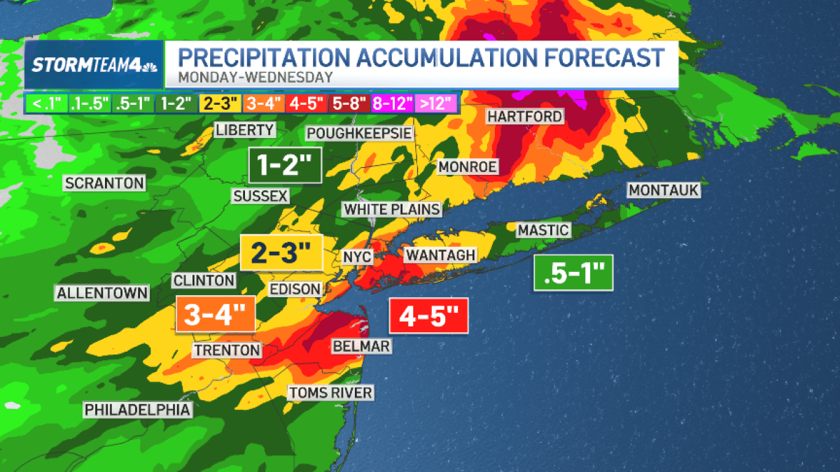
Storm Alert: NYC Area Braces for Dangerous Weather This Tuesday
What’s Happening Right Now
It’s another summer day in the New York City area, but Mother Nature has some serious plans. Powerful storms are rolling in this Tuesday, and they could bring big problems for the tri-state region.
IMPORTANT ALERT: These storms aren’t just your average summer rain showers. They pack multiple dangers that could affect you and your family.
The Big Three Threats
1. Major Flash Flooding
- Why it’s extra dangerous: The ground is already soaked from recent storms
- What this means: Rain has nowhere to go, so it piles up FAST
- Who’s at risk: Low-lying areas, basements, and roads with poor drainage
2. Damaging Straight-Line Winds
- What are they? Super-strong winds that blow in ONE direction (not spinning like a tornado)
- How strong? Strong enough to knock down trees, power lines, and damage buildings
- When? Most likely during afternoon and evening storms
3. Possible Tornadoes
- Chance level: Low but REAL possibility
- What to watch: Rotating clouds, loud roar like a freight train
- Action needed: Have a safe spot ready just in case
Where’s the Bullseye?
| Area |
Risk Level |
What to Expect |
| Central New Jersey |
HIGHEST RISK |
Strongest storms, biggest flood threat |
| South New Jersey |
HIGHEST RISK |
Same dangerous conditions |
| NYC & North Jersey |
MODERATE RISK |
Storms possible anywhere, anytime |
| Long Island |
MODERATE RISK |
Could see heavy rain and wind |
| Lower Hudson Valley |
MODERATE RISK |
Watch for sudden downpours |
KEY POINT: "Storms could hit anywhere in the tri-state and bring a deluge of rain at a moment’s notice." Don’t let your guard down just because you’re not in the "highest risk" zone!
Your 5-Step Safety Plan
Step 1: Stay Informed
- Check weather alerts right now at NBC New York Weather Alerts
- Enable emergency alerts on your phone
- Follow local news and National Weather Service on social media
Step 2: Prepare Your Home
- Clear gutters and storm drains if safe to do so
- Move cars to higher ground if you live in a flood-prone area
- Secure outdoor furniture, trash cans, and decorations
- Charge all devices and have flashlights ready
Step 3: Plan Your Travel
- Avoid unnecessary trips this afternoon and evening
- NEVER drive through flooded roads — just 6 inches of moving water can knock you down, 12 inches can float a car
- Check transit apps for delays/cancellations
- Allow EXTRA time if you must travel
Step 4: Know Your Safe Spots
- For tornadoes: Basement, interior room on lowest floor, away from windows
- For flooding: Get to higher ground immediately
- For high winds: Stay away from windows, avoid rooms with large trees outside
Step 5: Check on Others
- Text/call elderly neighbors and relatives
- Make sure kids know the plan
- Don’t forget pets — bring them inside!
CRITICAL REMINDERS
TURN AROUND, DON’T DROWN® — More people die in flooded cars than anywhere else during floods!
WHEN THUNDER ROARS, GO INDOORS — If you can hear thunder, you’re close enough to be struck by lightning!
DOWNED POWER LINES = STAY AWAY — Assume ALL downed wires are LIVE and deadly. Call 911!
Quick Summary
| What |
When |
Where |
Main Dangers |
| Severe Storms |
Tuesday afternoon & evening |
Entire tri-state area |
Flash flooding, damaging winds, possible tornadoes |
| Highest Risk |
Peak heating hours |
Central & South Jersey |
All three threats combined |
Bottom line: This isn’t a "wait and see" situation. The ground is already wet, the atmosphere is primed, and storms can explode quickly. Take action NOW to protect yourself and your loved ones.
Frequently Asked Questions
Q: What’s the difference between a watch and a warning?
A: Think of it like baking cookies:
- WATCH = Ingredients are out (conditions are RIGHT for bad weather). Be ready.
- WARNING = Cookies are in the oven (bad weather IS HAPPENING or imminent). Take action NOW!
Q: How much rain causes flash flooding?
A: It’s not just about total inches — it’s about SPEED. Even 1-2 inches in an hour can cause flash floods, especially since the ground is already saturated from recent storms. Urban areas flood faster because concrete doesn’t absorb water.
Q: What are "straight-line winds" and how are they different from tornadoes?
A: Straight-line winds blast outward in straight lines from a storm (like a giant hair dryer). Tornadoes spin violently. Both can cause similar damage — flattened trees, roof damage, flying debris — but straight-line winds affect a much wider area.
Q: Should I keep my kids home from after-school activities?
A: Yes, strongly consider it. Afternoon/evening is peak storm time. If activities are indoors at a sturdy building with a safety plan, it might be okay — but check with organizers first. When in doubt, keep them home.
Q: My basement flooded last week. What should I do differently this time?
A:
- Move valuables OFF the floor NOW — use shelves, pallets, or upstairs rooms
- Test your sump pump — pour water in the pit to make sure it kicks on
- Have a battery backup for the sump pump (power often fails during storms)
- Know your evacuation route — don’t wait until water is rising to figure it out
Stay safe, stay informed, and remember — stuff can be replaced. You can’t.
Article based on NBC New York weather alert for Tuesday severe weather threat.
 1
1