 11
11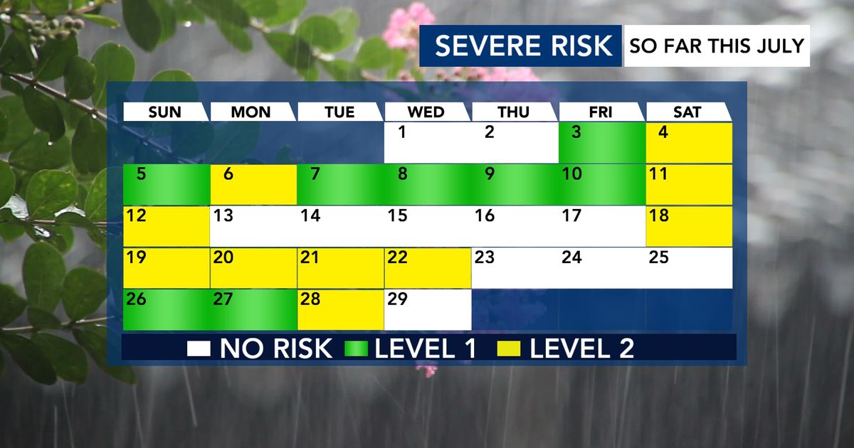
July has been the fourth-wettest on record in Raleigh. While the rain has mostly been a good thing, it’s also brought several threats of severe weather.
By the Numbers: 18 out of the first 28 days this month have been flagged for severe weather by NOAA’s Storm Prediction Center (SPC).
The Storm Prediction Center (SPC) is a part of NOAA (National Oceanic and Atmospheric Administration). They look ahead up to 8 days to figure out where damaging thunderstorms might pop up.
They use a 5-level scale to show how big the threat is:
| Level | Name | What It Means (In Plain English) |
|---|---|---|
| Level 1 | Marginal | Isolated severe storms possible — just a few here and there. |
| Level 2 | Slight | Scattered severe storms possible — more widespread than Level 1. |
| Level 3 | Enhanced | Numerous severe storms likely. |
| Level 4 | Moderate | Widespread severe storms, some intense. |
| Level 5 | High | Rare! Widespread, very dangerous storms expected. |
Key Difference:
- Isolated (Level 1) = A few storms, far apart.
- Scattered (Level 2) = More storms, covering a larger area.
So far this July, we’ve mainly seen Level 1 and Level 2 risks.
Let’s zoom in on Level 2 (Slight Risk) days — because Tuesday is one of them.
In July 2026, there have been 9 days with a Level 2 risk in our area.
Important Callout:
A Level 2 risk does NOT guarantee severe weather. It means conditions are favorable — but sometimes the storms don’t fire, or they stay weak.
Tuesday has a Level 2 risk, but there’s a real chance it fizzles out. Here’s why:
We’re tracking clusters of storms (called MCSs — Mesoscale Convective Systems) moving in from the Ohio River Valley.
| Scenario | What Happens | Severe Risk? |
|---|---|---|
| Cluster arrives around midday | Rain and clouds cool the air. This stabilizes the atmosphere, making it harder for strong storms to form later. | Low — the "cap" holds storms down. |
| Cluster misses us or comes late | The air stays warm and unstable. Afternoon heating fuels strong to severe storms. | Higher — especially for damaging winds. |
Simple Explanation:
Think of the morning storms like a wet blanket — they cool things off and take the energy away from afternoon storms.
It’s a government office (part of NOAA) that forecasts severe thunderstorms and tornadoes across the U.S. up to 8 days in advance.
Think: isolated = a few popcorn kernels popping; scattered = a handful popping at once.
No. It means conditions support severe storms, but they don’t always happen. In fact, 1 in 3 Level 2 days this July had zero damage reports.
A large, organized cluster of thunderstorms that can travel hundreds of miles. They often form at night or early morning and can bring heavy rain and wind.
Morning storms bring rain-cooled air that spreads out at the surface. This creates a stable layer (like a lid) that stops warm, moist air from rising — and rising air is what fuels thunderstorms.
Stay safe, stay informed, and keep an eye on the sky!