July Severe Risk Reality Check: How Often Do They Verify?
Raleigh’s Wet July: Understanding Severe Weather Risks and What to Expect
July So Far: Rainy with a Side of Storms
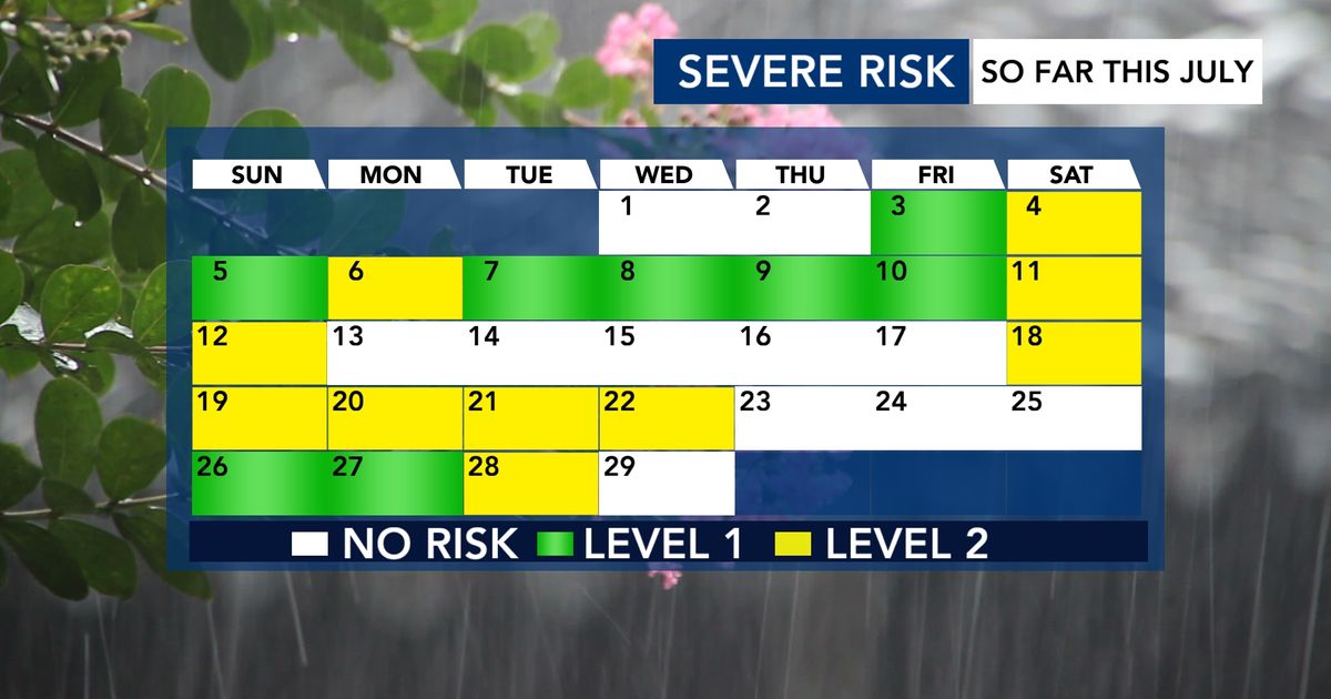
July has been the fourth-wettest on record in Raleigh. While the rain has mostly been a good thing, it’s also brought several threats of severe weather.
By the Numbers: 18 out of the first 28 days this month have been flagged for severe weather by NOAA’s Storm Prediction Center (SPC).
What Do These SPC Severe Risks Mean?
The Storm Prediction Center (SPC) is a part of NOAA (National Oceanic and Atmospheric Administration). They look ahead up to 8 days to figure out where damaging thunderstorms might pop up.
They use a 5-level scale to show how big the threat is:
| Level | Name | What It Means (In Plain English) |
|---|---|---|
| Level 1 | Marginal | Isolated severe storms possible — just a few here and there. |
| Level 2 | Slight | Scattered severe storms possible — more widespread than Level 1. |
| Level 3 | Enhanced | Numerous severe storms likely. |
| Level 4 | Moderate | Widespread severe storms, some intense. |
| Level 5 | High | Rare! Widespread, very dangerous storms expected. |
Key Difference:
- Isolated (Level 1) = A few storms, far apart.
- Scattered (Level 2) = More storms, covering a larger area.
So far this July, we’ve mainly seen Level 1 and Level 2 risks.
How Often Do These Risks Actually Lead to Damage?
Let’s zoom in on Level 2 (Slight Risk) days — because Tuesday is one of them.
In July 2026, there have been 9 days with a Level 2 risk in our area.
The Stats:
- Nearly 160 storm damage reports total across those 9 days.
- That’s an average of 18 reports per Level 2 day.
- But… 3 of those 9 days had ZERO damage reports.
Important Callout:
A Level 2 risk does NOT guarantee severe weather. It means conditions are favorable — but sometimes the storms don’t fire, or they stay weak.
What Could Stop Severe Weather on Tuesday?
Tuesday has a Level 2 risk, but there’s a real chance it fizzles out. Here’s why:
What We’re Watching:
We’re tracking clusters of storms (called MCSs — Mesoscale Convective Systems) moving in from the Ohio River Valley.
Two Scenarios:
| Scenario | What Happens | Severe Risk? |
|---|---|---|
| Cluster arrives around midday | Rain and clouds cool the air. This stabilizes the atmosphere, making it harder for strong storms to form later. | Low — the "cap" holds storms down. |
| Cluster misses us or comes late | The air stays warm and unstable. Afternoon heating fuels strong to severe storms. | Higher — especially for damaging winds. |
Simple Explanation:
Think of the morning storms like a wet blanket — they cool things off and take the energy away from afternoon storms.
Stay Informed & Prepared
- Download the WRAL Weather App for real-time alerts.
- Track storms live with DualDoppler5000 Radar.
Summary
- July is 4th wettest on record in Raleigh.
- 18 of 28 days had SPC severe weather outlooks.
- SPC uses a 1–5 scale; we’ve seen mostly Level 1 (isolated) and Level 2 (scattered) risks.
- 9 Level 2 days so far → ~160 damage reports (avg. 18/day), but 3 days had none.
- Tuesday = Level 2 risk, but morning storms from the west could cool the air and suppress afternoon severe weather.
- Stay alert, but don’t panic — risk ≠ guarantee.
FAQ: Your Questions Answered
1. What is the Storm Prediction Center (SPC)?
It’s a government office (part of NOAA) that forecasts severe thunderstorms and tornadoes across the U.S. up to 8 days in advance.
2. What’s the difference between “isolated” and “scattered” storms?
- Isolated = Very few storms, far apart (Level 1).
- Scattered = More storms, covering a bigger area (Level 2).
Think: isolated = a few popcorn kernels popping; scattered = a handful popping at once.
3. Does a Level 2 risk mean I’ll definitely get severe weather?
No. It means conditions support severe storms, but they don’t always happen. In fact, 1 in 3 Level 2 days this July had zero damage reports.
4. What is an MCS (Mesoscale Convective System)?
A large, organized cluster of thunderstorms that can travel hundreds of miles. They often form at night or early morning and can bring heavy rain and wind.
5. How can morning storms prevent afternoon severe weather?
Morning storms bring rain-cooled air that spreads out at the surface. This creates a stable layer (like a lid) that stops warm, moist air from rising — and rising air is what fuels thunderstorms.
Stay safe, stay informed, and keep an eye on the sky!