Chicago Weather Alert: Rain, Floods & Storms Coming Your Way!
Quick Note: This forecast was originally shared in Spanish on Univision Chicago. I’ve translated and simplified it so everyone can understand what’s coming!
What’s Happening Right Now?
Good morning, Chicago! It’s 6:45 AM and things are about to change big time.
| Yesterday & This Week |
Today & The Weekend |
| Sunny & calm |
Rain returns — and it means business |
| Dry roads |
Flooding possible |
| Warm |
Cooler temps coming |
The Big Picture: What You Need to Know
[!IMPORTANT]
This isn’t just a sprinkle. We’re looking at multiple rounds of heavy rain starting this afternoon and lasting through the weekend. Some areas could see 1–3+ inches of rain!
The Timeline
- Right Now (Morning Rush) — Mostly cloudy, roads dry, conditions calm
- Around Noon — First raindrops hit western areas
- 3:00 PM — Rain reaches Chicago proper & Northwest Indiana
- Tonight/Overnight — Heaviest rain expected
- Tomorrow Morning — More rain continues
- Saturday Afternoon & Sunday Morning — Possible extra rounds
- Monday — Finally! Calmer, drier weather returns
The Dangers: Why This Matters
1. Flooding Risk — Level 2 out of 5
Our entire area is under a flood watch.
- Streets could become rivers
- Low-lying areas = danger zones
- Underpasses & bridges = avoid if possible
[!WARNING]
NEVER drive through standing water.
Turn around, don’t drown!
2. Severe Storms Possible — Level 1 out of 5
Highest risk: Far southwest suburbs
- Interstate 39 corridor
- DeKalb, Kendall, SW Will County, W Kankakee
- Main threat: 60 mph wind gusts
- Can snap tree branches
- Damage fragile structures
Your Action Plan: 5 Steps to Stay Safe
- Check your route NOW — Find alternatives if your normal roads flood easily
- Prep your basement — Move valuables up, check sump pump
- Secure outdoor items — Patio furniture, trash cans, decorations
- Charge devices — Phones, power banks, flashlights
- Have an emergency kit — Water, snacks, meds, important docs
Beach Alert: No Swimming This Weekend!
Beach Hazard Statement: Active tonight through Monday
| Beaches Affected |
Why It’s Dangerous |
| Lake Cook County |
High waves + strong currents |
| Lake County (IL) |
Rip current risk |
| Porter County (IN) |
Dangerous swimming conditions |
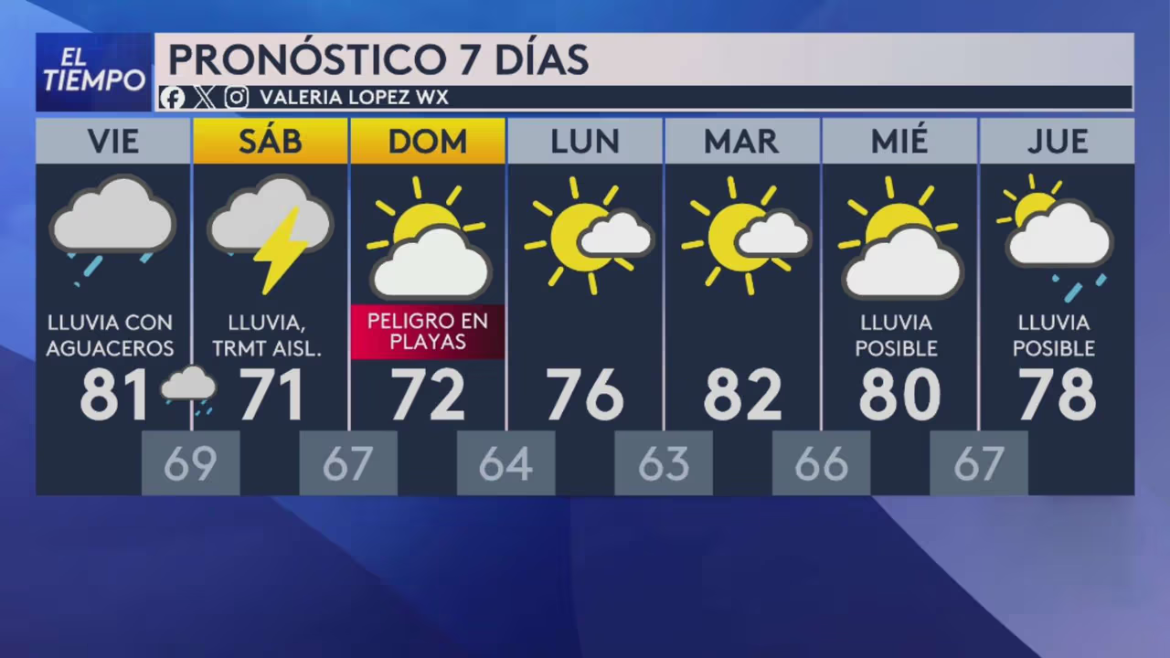
Bottom line: Stay out of the water Saturday & Sunday. It’s not worth the risk!
Temperature Rollercoaster
| Day |
High Temp |
Feels Like |
| Today |
Low 80s |
Muggy with rain |
| Saturday |
71°F |
Cool & wet |
| Sunday |
72°F |
Still damp |
| Monday |
76°F |
Finally nice! |
Rainfall Totals: What to Expect
| Time Period |
Expected Rainfall |
| Through Tonight |
0.5 – 1 inch |
| Overnight (Heaviest!) |
1 – 3+ inches (isolated spots) |
| Saturday + Sunday |
Additional if storms linger |
| Total Potential |
Several inches in some areas |
Summary: TL;DR
- Heavy rain starts this afternoon, lasts through weekend
- Flood risk = HIGH — don’t drive through water!
- Severe storms possible SW of city — 60 mph winds
- Beaches closed for swimming Sat–Mon
- Temps drop from 80s → 70s → nice Monday
- Prep NOW — basement, routes, emergency kit
Frequently Asked Questions
Q: Should I cancel my weekend plans?
A: Outdoor plans? Probably yes. Indoor plans? You’re good — just stay off flooded roads and away from the lakefront.
Q: My street floods every time. What should I do?
A: Move your car to higher ground TODAY. Sandbag if you have them. Have a "go bag" ready in case you need to leave quickly.
Q: How do I know if a road is flooded?
A: Check IDOT traffic maps, Google Maps/Waze (red = bad), or local news. When in doubt, don’t go out.
Q: What’s the difference between a "watch" and a "warning"?
A:
- Watch = "Conditions are right for trouble. Be ready."
- Warning = "Trouble is happening NOW. Take action!"
Right now we have a Flood Watch — so BE READY.
Q: When will this finally end?
A: Monday looks like the first truly dry, pleasant day. Hang in there!
Stay safe, Chicago!
Keep checking local forecasts — weather changes fast. This article is based on the morning forecast and conditions may update.
 1
1