11
11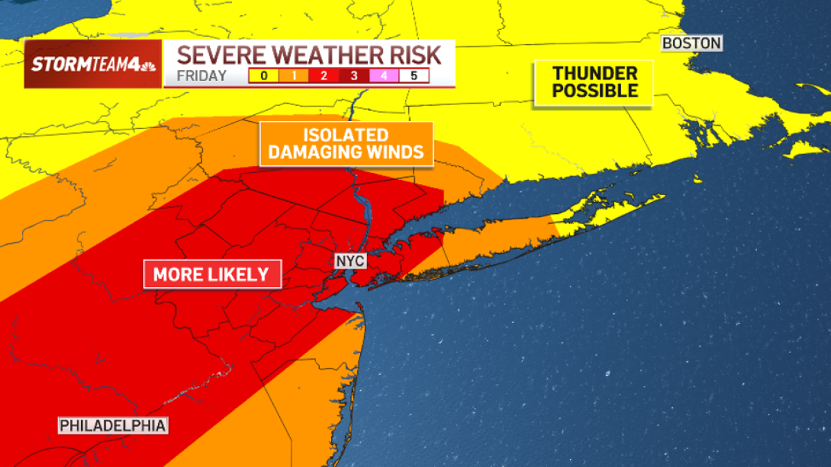
Listen up, tri-state neighbors! Mother Nature is planning a rowdy Friday afternoon and evening across New York City, the lower Hudson Valley, north and central New Jersey, and all the way down to Washington, D.C.
Meteorologists (weather scientists) have issued an elevated threat for severe storms. Think of it like a "heads up" from the weather team — they’re telling us to pay attention because strong storms are likely.
Weather experts use a scale from 1 to 5 to rate storm risks:
Right now, we’re at Level 2.
That means: "Be prepared. Storms could get strong, but it’s not the worst-case scenario."
Areas under Level 2 threat:
- All five NYC boroughs
- Lower Hudson Valley
- North & central New Jersey
- Southwest to Washington, D.C.
Not all storm threats are created equal. Here’s what IS and ISN’T likely:
| Threat | Likelihood | What It Means |
|---|---|---|
| Damaging straight-line winds (60+ mph) | HIGH | Winds that blow straight out from a storm — not spinning like a tornado. Can snap trees, knock down power lines, and damage roofs. |
| Flash flooding | LOW-MODERATE | Sudden flooding from heavy rain. Possible in poor-drainage areas. |
| Tornadoes | VERY LOW | Spinning funnels of wind. Not expected. |
| Large hail | VERY LOW | Ice balls falling from sky. Unlikely. |
Straight-line winds vs. tornadoes:
Imagine a fan blowing straight at you — that’s straight-line wind. A tornado is like a spinning top. Both dangerous, but different!
Storms follow a schedule. Here’s your hour-by-hour game plan:
Severe Thunderstorm Watch = "Conditions are right for bad storms. Stay alert!"
Warning = "A bad storm IS happening NOW. Take cover!"
| Area | Expected Rain |
|---|---|
| Most places | Under 1 inch |
| Unlucky spots | 2–4+ inches (quickly!) |
Why the big difference?
The air is soaked with moisture — like a wet sponge. When storms squeeze it, rain pours fast.
Good news: Storms are moving along (not stuck in place). "Training" — when storms line up like train cars over the same spot — is unlikely. That keeps totals from getting crazy.
| Day | Rain Chance | What to Expect |
|---|---|---|
| Saturday | Lower | A few afternoon/evening storms possible |
| Sunday | Near Zero | Dry, pleasant — great outdoor day! |
DO:
- Charge phones & power banks now
- Have flashlights ready (not candles!)
- Know where your safe room is (interior, no windows)
- Check on elderly neighbors
DON’T:
- Drive through flooded roads (6 inches of water can stall a car!)
- Stand near windows during high winds
- Assume "it won’t hit me" — storms are isolated but anywhere in the zone is at risk
- Forget pets — bring them inside!
| Key Fact | Details |
|---|---|
| Threat Level | Level 2 of 5 (Elevated) |
| Main Danger | 60+ mph straight-line winds |
| Watch Until | 9 PM Friday |
| Peak Time | 4–9 PM (dinner through evening) |
| Rain Most Areas | < 1 inch |
| Rain Unlucky Spots | 2–4+ inches |
| Tornadoes/Hail? | Very unlikely |
| Saturday | Few storms possible |
| Sunday | Beautiful, dry day |
Bottom line: Friday afternoon/evening = stormy & windy. Stay inside during the peak. Weekend = much better!
Nope! Straight-line winds blow in one direction (like a giant fan). Tornadoes spin. Both can cause damage, but they’re different. Today’s threat is straight-line winds.
If they’re outdoors between 4–9 PM — yes, have a backup plan. Indoor reservations? You’re fine, just allow extra travel time.
It’s possible. 60+ mph winds can knock down lines. Charge devices now and prep flashlights.
Yes! High pressure builds in = sunny, dry, comfortable. Perfect for outdoor plans.
Stay safe, stay dry, and enjoy the weekend!
Article based on NBC New York weather forecast for Friday, August 2026.