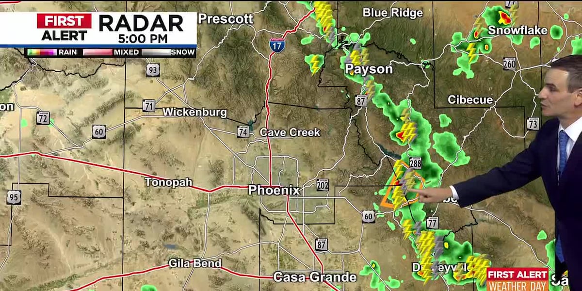
Big Weather Alert: Storms, Dust, and Cooling Temps Heading to Phoenix!
Hey there! Imagine Mother Nature is throwing a bit of a tantrum right now—loud thunder, super-fast winds, hail like marbles, and even a giant wall of dust. But don’t worry! We’re here to break it all down like you’re five years old so you know exactly what’s happening and how to stay safe.
What’s Happening Right Now (Sunday Evening)
The National Weather Service (that’s the official weather experts) has issued a Severe Thunderstorm Warning for Phoenix, Glendale, and Peoria. Think of this like a loud alarm bell saying: "Hey! Dangerous weather is happening NOW or coming very soon!"
The Scary Stuff to Watch For:
- Super Speedy Winds: Up to 80 mph! That’s faster than cars drive on the highway. These winds can knock down trees, break power lines, and send trampolines flying.
- Hail Stones: Real hail was spotted falling at North Mountain Park in Phoenix. Some pieces might be as big as quarters or even golf balls—ouch!
- A Giant Dust Wall: A massive "haboob" (that’s a fancy word for a huge dust storm) is rolling north from south of I-8 in Maricopa and Pinal Counties. It looks like a brown wall in the sky and turns day into night.
IMPORTANT ALERT
The National Weather Service says this dust storm could reach the Phoenix area within about 1 HOUR.
If you’re driving and see a wall of dust: PULL ASIDE, STAY ALIVE! Turn off your lights, take your foot off the brake, and wait for it to pass.
Today’s Temperature Rollercoaster
- Peak Heat: It hit 111°F this afternoon!
- Good News: The Extreme Heat Warning expired at 8 PM. That means the dangerous heat level has dropped, but it’s still warm out.
Your Easy-to-Read 5-Day Forecast
| Day |
High Temp |
Rain/Storm Chance |
What to Expect |
| Monday |
108°F |
30% (Night) |
A bit cooler. Storms likely Monday night into early Tuesday. |
| Tuesday |
104°F |
20% (Night) |
Nice cooling trend continues. Small storm chance Tuesday night. |
| Wednesday |
101°F |
30% (Evening) |
First day near 100°! Storms possible Wednesday evening. |
| Thursday |
100°F |
Slight Chance |
Only 100°! Tiny chance of an afternoon/evening storm. |
| Friday |
103°F |
Low |
Pleasant by Phoenix standards. Great end to the workweek! |
| Weekend |
106–108°F |
Low |
Heat creeps back up. Typical summer vibes return. |
ELI5 EXPLANATION:
Think of the week like a slide at a playground. We start high (111°), slide down to a comfy 100° by Thursday, then climb the ladder again for the weekend.
Other Alerts You Should Know
Flood Watch – Southern Arizona (Including Tucson)
- When: Monday afternoon through Monday evening
- What it means: Heavy rain could cause flash flooding. Washes (dry riverbeds) can fill up fast—never drive through flowing water!
High Country Storms – Northern & Eastern Arizona
- Tonight: Isolated storms
- Mon–Thu: More widespread storm activity
- If you’re camping/hiking up there: Keep an eye on the sky and have a way to get alerts.
5 Simple Steps to Stay Safe Tonight
- Stay Indoors – Best place during severe storms and dust.
- Secure Loose Stuff – Trampolines, patio furniture, trash cans—tie them down or bring them in.
- Charge Your Phone – In case power goes out, you’ll want a full battery.
- Don’t Drive in Dust – If you’re caught in the haboob: Pull over, lights off, foot off brake.
- Keep a Flashlight Handy – Power flickers happen with 80 mph winds.
Quick Summary
- Right Now: Severe storms with 80 mph winds, hail, and a massive dust storm approaching Phoenix.
- Tonight: Dust could arrive within the hour. Outflow winds and blowing dust possible from storms south/east of the Valley.
- This Week: Nice cooling trend! Highs drop from 108° Monday to 100° Thursday. Storm chances each night (20–30%).
- Watch Out: Flood Watch for Tucson/southern AZ Monday. High country storms Mon–Thu.
- Weekend: Heat returns to 106–108°.
FAQ – Your Questions Answered
1. What exactly is a "haboob"?
It’s a giant wall of dust pushed by strong winds from a collapsing thunderstorm. It can be thousands of feet high and miles wide. It looks scary but usually passes in 15–30 minutes.
2. Should I pick up my kids from practice/activities?
If they’re outdoors right now—yes, get them inside. If it’s later tonight and storms have passed, use your best judgment. When in doubt, wait it out.
3. Will the power go out?
With 80 mph winds, it’s possible. Trees and branches falling on lines are the main cause. That’s why charging your phone now is smart.
4. Is it safe to drive Monday morning?
Most likely yes! The worst weather is Sunday night into Monday morning. By Monday daytime, it should just be warm (108°) with storms holding off until night.
5. Why does the forecast say "30% chance" – does that mean it WILL rain?
Nope! 30% chance means: If we had 10 days exactly like this, it would rain on 3 of them. It’s a "maybe," not a "definitely." Always good to have an umbrella handy though!
Stay safe, stay informed, and keep looking up!
Source: National Weather Service Phoenix & AZFamily Weather Team
Copyright 2026 KTVK/KPHO. All rights reserved.
 1
1