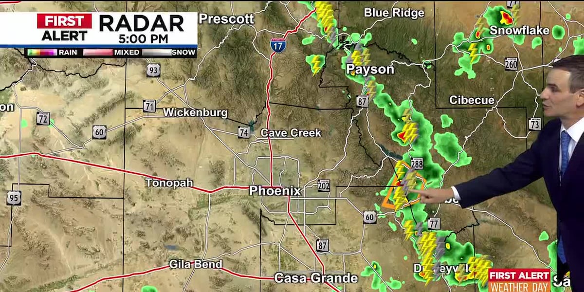
Big Storms Hit Phoenix: What You Need to Know Right Now
What’s Happening Right Now?
A line of strong storms has moved into the Phoenix area, bringing dangerous weather to several cities. The National Weather Service has issued a Severe Thunderstorm Warning for:
IMPORTANT ALERT: This is not just a regular rainstorm. These storms can cause damage and be dangerous if you’re not prepared.
The Big Three Dangers
1. Super Strong Winds
- Winds could reach 80 mph (that’s hurricane force!)
- Strong enough to knock down trees, power lines, and damage roofs
- Can blow around unsecured outdoor items like patio furniture, trampolines, and trash cans
2. Hail Stones
- Hail already reported at North Mountain Park in Phoenix
- Hail can dent cars, break windows, and hurt people or pets caught outside
- Size can range from pea-sized to golf ball-sized or larger
3. Massive Dust Wall (Haboob)
- A giant wall of dust spotted south of I-8 in southern Maricopa County
- Moving west and north toward Phoenix
- Dust Storm Warning already issued
- Could reach Phoenix area within 1 hour
- Visibility can drop to near zero in seconds
Today’s Heat Recap
- High temperature: 111°F (that’s really hot!)
- Extreme Heat Warning expired at 8:00 PM tonight
- Storms developing south and east of Phoenix could send outflow winds and blowing dust into the Valley tonight
- Slight chance of a shower or thunderstorm in the Valley tonight
Your 7-Day Forecast (The Good News: It’s Cooling Down!)
| Day |
High Temp |
Rain/Storm Chance |
What to Expect |
| Tonight |
— |
Slight chance |
Possible storms, blowing dust |
| Monday |
108°F |
30% (night) |
Cooler, storms Mon night → Tue AM |
| Tuesday |
104°F |
20% (night) |
Even cooler, storms Tue night → Wed AM |
| Wednesday |
101°F |
30% (evening) |
Continuing cool down, evening storms |
| Thursday |
100°F |
Slight chance |
Near 100°, possible afternoon/evening storm |
| Friday |
103°F |
Low |
Pleasant by Phoenix standards! |
| Weekend |
106-108°F |
Low |
Warming back up |
Good News: We’re on a cooling trend! By Wednesday, highs drop to 101°F, and Thursday might only hit 100°F.
Other Weather Alerts Across Arizona
Flood Watch – Southern Arizona (Including Tucson)
- When: Monday afternoon through Monday evening
- What: Heavy rain could cause flooding in washes, low-lying areas, and streets
- Action: Never drive through flooded roadways — "Turn Around, Don’t Drown!"
High Country (Northern & Eastern Arizona)
- Tonight: Isolated showers and thunderstorms
- Monday through Thursday: Widespread storm activity expected
- Hazards: Lightning, heavy rain, gusty winds, possible small hail
How to Stay Safe Right Now (Numbered Steps)
- Get Inside Immediately — If you’re outside, go indoors now. A sturdy building is best.
- Stay Away from Windows — High winds and hail can shatter glass. Move to an interior room.
- Secure Outdoor Items — If safe to do so quickly, bring in or tie down patio furniture, grills, trampolines, etc.
- Don’t Drive in the Dust Storm — If you encounter the dust wall:
- Pull off the road as far as possible
- Turn off all lights (so others don’t follow your taillights)
- Set parking brake
- Wait for it to pass
- Stay Informed — Keep a weather app, radio, or TV on for updates. Follow @NWSPhoenix on X (Twitter).
- Charge Devices — Power outages are possible with 80 mph winds.
- Check on Neighbors — Especially elderly or vulnerable folks who might need help.
Quick Safety Checklist
- Phone charged + portable charger ready
- Flashlights (not candles!) accessible
- Emergency kit: water, snacks, meds, first aid
- Know your safe spot (interior room, no windows)
- Pets inside and secure
- Car in garage or away from trees
- Weather alerts ON for your phone
Summary
Right now: Severe storms with 80 mph winds, hail, and a massive dust wall are affecting the Phoenix metro area. Take shelter immediately.
The upside: A cooling trend starts Monday! Highs drop from 111°F today to around 100°F by Thursday. Storm chances continue through midweek, then we get a pleasant Friday before warming up again next weekend.
Other concerns: Flood Watch for Tucson/southern Arizona Monday. Widespread storms in northern/eastern Arizona high country Monday-Thursday.
Stay safe, stay inside, and stay informed!
FAQ: Your Questions Answered
Q: What exactly is a "haboob"?
A: A haboob (ha-BOOB) is a giant wall of dust created by strong winds rushing out of a thunderstorm. It can be thousands of feet high and miles wide. Visibility drops to near zero in seconds. It’s Arabic for "blasting wind" — and that’s exactly what it feels like!
Q: The warning says "until 8 PM" but it’s already 7:45 PM. Am I safe?
A: Not necessarily! Warnings are often extended if storms persist. Plus, the dust storm could arrive after the thunderstorm warning expires. Keep sheltering until official "all clear" from NWS.
Q: Can I drive home if I’m already on the road?
A: Only if you’re minutes from safety. If you see the dust wall ahead, pull over NOW (see steps above). Don’t try to "outrun" it — 80 mph winds and zero visibility make driving extremely dangerous.
Q: My power just went out. What should I do?
A:
- Report it to your utility (APS, SRP, etc.)
- Use flashlights, not candles (fire risk)
- Keep fridge/freezer closed (food stays safe 4+ hours)
- Check on neighbors
- Stay inside — downed power lines may be hidden by debris/dust
Q: When will the "Extreme Heat" come back?
A: Next weekend (Saturday/Sunday) highs climb back to 106-108°F. But it won’t be as brutal as today’s 111°F. Still, stay hydrated and limit outdoor time during peak heat!
Stay weather-aware, Arizona!
Source: AZFamily / National Weather Service Phoenix | Copyright 2026 KTVK/KPHO. All rights reserved.
 1
1