Houston’s Heavy Rain Day: A Super Simple Explain-as-If-You’re-5 Guide
What’s the Big News?
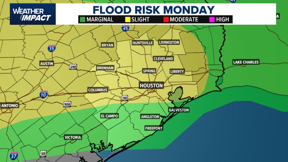
Today (Monday), the Houston area is going to get a lot of rain — like when you leave the sprinkler on too long! The whole area is under a "Level 2" flood warning. That’s a fancy way of saying there’s a slight chance (not huge, but real) that water might cause problems on streets.
A special heads-up called a Weather Impact Alert is in effect. Think of it like a teacher saying, "Hey, watch out, the weather might mess up your plans today."
- The rain will come in rounds during the afternoon.
- Even though we are not expecting scary storms (like tornadoes or big hail — that’s what "severe weather" means), the slow, heavy rain could make roads tricky during lunch and when people drive home in the evening.
Important Point: Slow-moving downpours can make roads hazardous even if there’s no big storm. Be careful!
What’s the Biggest Concern?
The main worry is heavy rainfall that could overwhelm streets and low-lying areas — imagine the gutters and streets filling up like a bathtub because water comes faster than it can drain, especially where the same rain cloud sits over the same spot again and again.
- Some neighborhoods could get 2 to 3 inches of rain (that’s like a few big water bottles stacked on every square foot!).
- If storms keep dumping water on the exact same place, isolated areas might see 3 to 5 inches or more.
Important: The primary threat is water on streets and in low spots, not wind or storms.
When Will the Rain Arrive? (Timing)
Here’s a simple timeline of the day:
- Early morning: A few isolated showers (small rain patches) might appear, mainly east of Houston. Your morning drive should be okay.
- Morning commute: Most of the time, roads should be manageable (not too bad).
- Lunch through afternoon (Noon–6 p.m.): This is the time to watch most closely! Storms will become more common around lunchtime and then spread across the whole Houston city area (metro) in the afternoon. The heaviest rain might stick around into the evening drive home, making travel slow.
- Later tonight: The heavy rain should slowly stop, but a few stray showers may continue in some spots.
Who Could See the Heaviest Rain?
Most of Southeast Texas has a chance to see rain that adds up today. But some places might get more:
- The North Freeway corridor (the area along that big road north of Houston).
- Areas along the Katy Freeway during the afternoon drive.
- Places north and west of Houston toward Bryan-College Station and closer to the Interstate 35 corridor (another big highway) are expected to get higher totals.
Travel Impacts
If you’re in a car, be ready for changing road conditions this afternoon. Water can appear in these spots:
- On roads during the lunch hour and evening commute.
- Under highway overpasses (the bridges that go over other roads).
- On bridges where water can collect quickly.
Never drive through flooded roadways. It’s dangerous — you can’t tell how deep the water is. Turn around, don’t drown!
Also, allow extra travel time.
How to Prepare (Step-by-Step)
Here are easy steps to get ready for the rain:
- Keep an umbrella handy if you’ll be outside this afternoon.
- Check the radar (a special map that shows where rain is) before heading out.
- Allow extra time for travel — leave earlier than usual.
- Watch for water-covered roads and areas that often flood.
- If possible, avoid unnecessary travel during the heaviest downpours.
Looking Ahead
The wet pattern isn’t over yet — more rain is coming!
- Tuesday: Another Weather Impact Alert is in effect. Heavy rain is expected to arrive earlier in the day, possibly making the morning drive messy, especially along the I-10 corridor (a big east-west road) and nearer to the coast.
- Wednesday: Rain chances go down a bit, with only isolated showers expected later in the week.
- Weekend: Drier weather should arrive — yay, sunshine!
Counties We Serve
Our weather info covers these counties and their main towns (just so you know if you’re in the area):
- Harris County: Houston, Pasadena, Baytown
- Fort Bend County: Richmond, Sugar Land, Missouri City
- Montgomery County: Conroe, The Woodlands
- Brazoria County: Angleton, Pearland, Alvin, Lake Jackson
- Galveston County: Galveston, League City, Texas City
- Liberty County: Liberty, Cleveland, Dayton
- Walker County: Huntsville, New Waverly
- Waller County: Hempstead, Prairie View, Waller
- Polk County: Livingston, Corrigan
- Chambers County: Anahuac, Mont Belvieu, Winnie
- Wharton County: Wharton, El Campo
- Washington County: Brenham
- Matagorda County: Bay City, Palacios
- Grimes County: Anderson, Navasota
- Austin County: Bellville, Sealy
- Colorado County: Columbus, Eagle Lake, Weimar
- Trinity County: Groveton, Trinity
Summary
To wrap it up: Houston is under a slight flood threat (Level 2) with a Weather Impact Alert today. Heavy rain, not scary storms, is the main issue. The worst time is noon to 6 p.m., with possible 2–3 inches of rain (more in spots). Roads may flood, especially near freeways and bridges. Prepare by carrying an umbrella, checking radar, leaving early, and never driving into water. Tuesday brings another rainy alert, but drier days come by the weekend. Stay safe!
FAQ
Q1: What is a "Weather Impact Alert"?
A: It’s a simple heads-up from the local weather team that the weather will likely affect your daily plans, like commuting or outdoor play. It’s not a severe storm warning, just a "be aware" notice.
Q2: Will there be tornadoes or severe weather?
A: No. The original info says severe weather is not expected. That means no tornadoes, no damaging winds, or large hail. Just plain heavy rain.
Q3: What should I do if I see a flooded road?
A: Never drive through it! Water can hide deep holes or sweep your car away. Turn around and find another route. This is super important.
Q4: When is the riskiest time to be on the road today?
A: The lunch hour through the evening commute, especially between Noon and 6 p.m., because that’s when the heaviest rain is most likely.
Q5: What about tomorrow (Tuesday)?
A: Another Weather Impact Alert is issued for Tuesday. Rain may come earlier and mess up the morning drive, particularly near I-10 and the coast.
 1
1