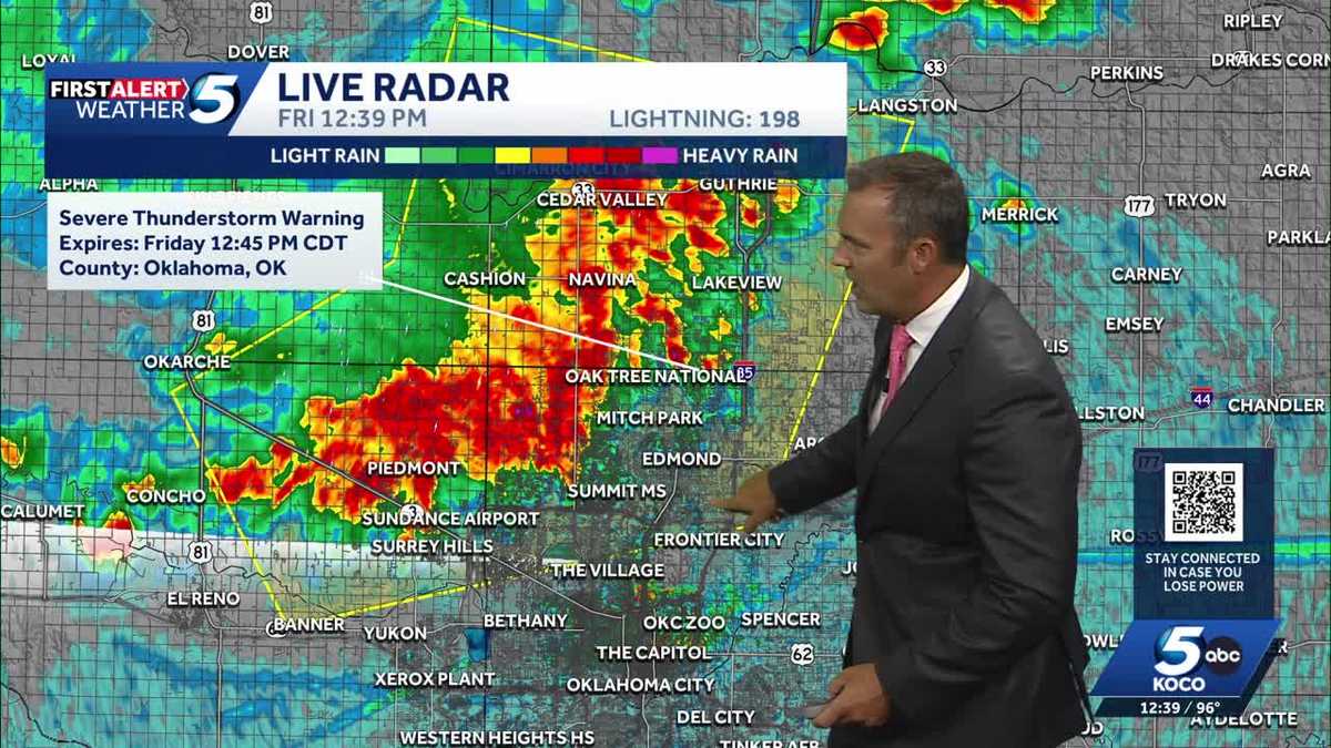
Oklahoma Weather Alert: Hot Friday with Severe Storms Possible in the North
What’s Happening Today?
Hey there! If you live in Oklahoma, you’re going to want to pay attention to the weather today. It’s going to be really hot — like, triple-digit hot — but that’s not the only thing going on. Parts of the state might also get some scary strong storms later today.
IMPORTANT POINT: Temperatures will hit 100°F or higher today, and with humidity, it’ll feel even hotter. Stay cool and hydrated!
Where Are the Storms Expected?
The northern half of Oklahoma is under a "Level 1 Marginal Risk" for severe weather. That’s weather-speak for "storms could get strong, but they’ll be scattered and not everywhere."
Cities in the Risk Zone:
- Elk City
- Clinton
- Oklahoma City (OKC)
- Shawnee
- Seminole
- Areas north of McAlester
IMPORTANT POINT: If you live south of this line (roughly), your storm risk is much lower — but it’ll still be super hot!
What Kind of Bad Weather Could Happen?
If a storm does pop up near you, here’s what it could bring:
| Threat |
Details |
| Damaging Winds |
Up to 70 mph — that’s hurricane-force! Can knock down trees and power lines. |
| Large Hail |
Up to 1 inch (quarter-sized) — can dent cars and damage roofs. |
| Flash Flooding |
Heavy rain in a short time — never drive through flooded roads! |
| Tornadoes |
NONE expected — zero tornado risk with these storms. |
IMPORTANT POINT: These storms will be isolated — meaning most places won’t see one, but any storm that forms could be strong.
When Will Storms Arrive? (Timeline)
Here’s the hour-by-hour breakdown from Meteorologist Jonathan Conder:
3:00 PM — Storms Fire Up
- Thunderstorms start in western Oklahoma
- They’ll move east toward the OKC metro area
7:00 PM — Storms Shift South
- Activity drops into southwestern Oklahoma
- Also affects the Texas Panhandle
10:00 PM — Lingering Showers
- Scattered showers possible in southern & eastern Oklahoma
- Storm energy fading, but rain still possible
Overnight — Clearing Out
- All rain moves out
- Sets up a hot weekend ahead
How to Stay Safe (Step-by-Step)
- Check the forecast often — Things can change fast!
- Have a way to get alerts — Weather app, NOAA radio, or KOCO 5 app
- If a warning is issued for your area:
- Go inside a sturdy building
- Stay away from windows
- Avoid mobile homes/vehicles if winds hit 70 mph
- Never drive through flooded roads — Turn around, don’t drown!
- Secure outdoor items — Trampolines, patio furniture, trash cans can become missiles in 70 mph winds
- Check on neighbors — Especially elderly or those without AC in this heat
Why Trust This Forecast?
The KOCO 5 First Alert Weather Team, led by Chief Meteorologist Damon Lane, has been certified by WeatheRate as providing the Most Accurate Forecast in Oklahoma City for 14 years in a row!
That means when they say "70 mph winds possible," you should take it seriously.
Summary
- It’s HOT — 100°F+ across Oklahoma today
- Northern OK has a Level 1 storm risk (Elk City to north of McAlester)
- Main threats: 70 mph winds, 1-inch hail, flash flooding
- No tornadoes expected
- Storms arrive ~3 PM west, move east, fade by midnight
- Weekend looks hot & dry after tonight
- KOCO 5 = 14-time most accurate forecast in OKC
Stay weather-aware, stay cool, and have a safe Friday!
FAQ
What does "Level 1 Marginal Risk" mean?
It’s the lowest severe weather category. It means: "Isolated severe storms possible, but not widespread." Most people won’t see a storm — but if you do, it could be strong.
Should I cancel outdoor plans?
If you’re in the risk zone (northern OK), have a backup plan. Keep an eye on radar after 3 PM. If storms aren’t near you by 7 PM, you’re probably good.
How do I know if a warning is issued for my location?
- Download the KOCO 5 app (free) and enable alerts
- Get a NOAA Weather Radio ($20-30, works without internet)
- Follow @KOCO5Weather on social media
What’s the difference between a Watch and a Warning?
- Watch = "Ingredients are there, stay ready" (issued hours ahead)
- Warning = "It’s happening NOW or imminent, take shelter!" (issued for specific counties)
Will this affect my weekend plans?
Storms end overnight. Saturday & Sunday look hot and dry — great for pools/lakes, but drink water and use sunscreen!
 1
1