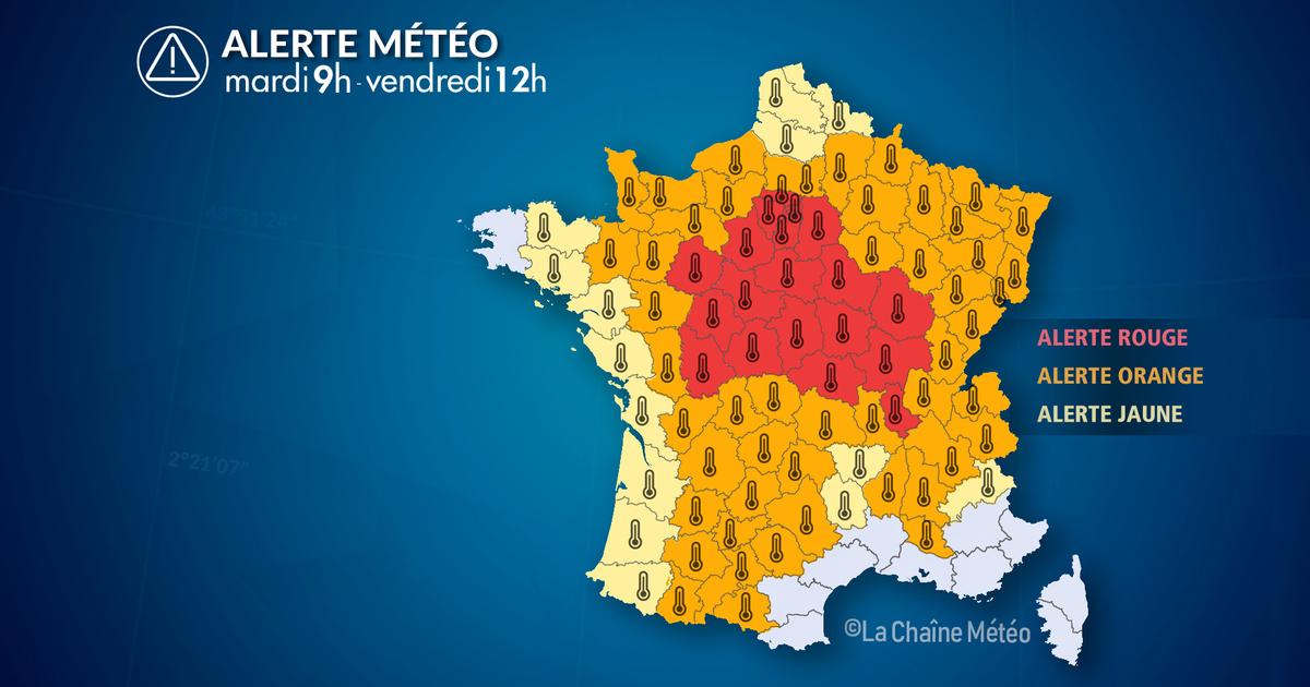
ALERTE MÉTÉO : Canicule Alerte Rouge, danger imminent
France’s Big Heatwave: A Simple Guide to the Hot Days (July 14–17, 2026)
When Is This Happening?
- Start: Tuesday, July 14, 2026 at 9:00 in the morning.
- End: Friday, July 17, 2026 at 12:00 noon (midday).
During this time, a very strong heatwave (a period of extremely hot weather) will affect France.
What’s Going On? (The Situation)
Imagine the weather like a big pot of soup. Right now, a giant "high‑pressure blanket" (scientists call it an anticyclone) is sitting on top of Western Europe and France. This blanket keeps the sky clear and calm. Under it, a huge "heat lid" (called a heat dome) stretches from Spain all the way to France, trapping warm air like a cover on a pot.
At the same time, a cold drop (a small cool pocket high in the sky near the Atlantic Ocean) is acting like a vacuum cleaner for heat: it pulls super hot air from the south straight into France. Think of it as a heat pump that pushes hot air upward and northward.
IMPORTANT RED ALERT: A top‑level danger warning is active for 22 departments (like local counties) from the center‑west of France, through the Paris area, to the center‑east.
- Even early in the morning, temperatures are already between 22°C and 25°C (very warm!).
- In the afternoon, it will climb to 36°C–40°C (that’s as hot as a sauna!).
The hottest peak is in the middle of this week (around Wednesday).
Starting Thursday, cooler ocean air from the Atlantic will begin to push the heat away. But this change will bring thunderstorms (strong rain and lightning) that could be loud and powerful. We need to watch these storms carefully; they might also trigger new warnings from the weather service.
By Friday, the heatwave will mostly be over for much of France. However, the southeast corner will still be baking with 35°C–40°C. Local winds called mistral and tramontane can blow near the Mediterranean Sea and, because of a "warm wind effect" (foehn effect—when air drops from mountains and gets hotter), they can make temperatures even higher.
Also, the ground is getting very dry. Plants are like crackers now, which makes it easier for fires to start.
What We Saw on Tuesday Morning (Observation)
The night before was a "tropical night"—that means it stayed as warm as a beach night, never dropping below 20°C in most big cities. It was a sign that Tuesday would be another scorcher.
Here are the temperatures measured at 7:00 AM on Tuesday:
- 27°C in Toulon (department 83)
- 25°C in Dole (25)
- 24°C in Le Mans (72)
- 23°C in Lyon (69)
- 22°C in Toulouse (31), Albi (81), and Clermont‑Ferrand (63)
- 21°C in Paris (75) and Strasbourg (68)
Want to know the weather in your own town? You can check it here: Consult the weather for your city.
How Things Will Change (Evolution)
- Until Wednesday: The heatwave continues. Nights stay tropical (warm everywhere), and daytime heat is intense—up to 40°C in central France.
- Thursday: The southwest to east parts still bake at 36°C–39°C. Near the Atlantic, temperatures start to dip a little, but the air feels heavy and sticky, and thunderstorms begin.
- Friday: Thunderstorms will gradually cool most of the country. The southeast, however, stays hot at 35°C–38°C.
Summary
From July 14 to July 17, 2026, France faces a severe heatwave caused by a high‑pressure blanket, a heat dome, and a heat‑pumping cold drop. A red alert covers 22 departments with morning lows of 22–25°C and afternoon highs of 36–40°C. Tropical nights are happening. The heat peaks mid‑week, then Atlantic air brings thunderstorms and relief from Thursday, though the southeast remains very hot (35–40°C on Friday per the overall situation, and 35–38°C per the detailed evolution). Dry conditions raise fire risk. Stay safe, drink water, and check local forecasts.
FAQ (Frequently Asked Questions)
1. What is a "tropical night" in simple words?
It’s a night when the temperature never goes below 20°C, just like warm nights in the tropics. It makes you feel like the bedroom is still a hot afternoon.
2. Why is there a red alert for 22 departments?
Red is the highest warning level. It means the heat is so strong (36–40°C days, warm nights) that it can be dangerous for everyone, not just sensitive people. The alert covers areas from west‑central France to Paris and east‑central France.
3. What is a "cold drop" and how does it make things hotter?
A cold drop is a cool bubble of air high up in the atmosphere over the ocean. Instead of cooling the land, it acts like a pump that sucks hot air from Spain and Africa up into France, making our days super hot.
4. What is the foehn effect mentioned for the mistral wind?
When wind like the mistral blows over mountains and comes down the other side, the air gets squeezed and warms up. So near the Mediterranean, this wind can make an already hot day even hotter.
5. Will the heat end everywhere on Friday?
Almost everywhere, yes, because of thunderstorms. But the southeast part of France will still be very hot (35–38°C according to the step‑by‑step forecast, and up to 40°C in the general Friday picture) even after the rest cools down.