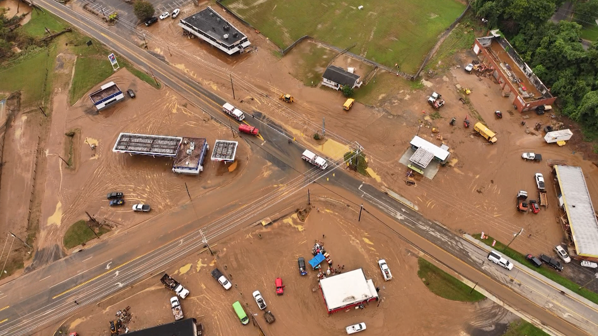
URGENT: Severe Storms Slam NC & VA — Live Tracker Now
Severe Weather Hits North Carolina & Virginia: What You Need to Know (Simple Guide)
Location: Winston-Salem, N.C. | Date: Sunday (updates throughout the day)
Main Threat: Severe thunderstorms, damaging winds (58+ mph), flash flooding, and mudslides
Real-Time Storm Timeline: What Happened & When
Here’s a simple breakdown of events as they unfolded, from earliest to latest:
| Time | Event | Why It Matters |
|---|---|---|
| 1:43 a.m. | Flash flooding reported in Ararat, Virginia (Hunters Chapel Road) | Water rose fast—roads covered, fields flooded |
| 1:50 a.m. | Mudslide near Woodville, northern Surry County | Ground gave way after heavy rain |
| 7:30 a.m. | Mount Airy declares State of Emergency | City officially recognizes danger level |
| 10:50 a.m. | Fire crews clearing mud/debris near Riverside Park | Roads blocked, cleanup underway |
| 11:15 a.m. | 4 parks + entire greenway closed in Mount Airy | Riverside, HB Rowe, Tharrington Parks + Granite City Greenway |
| 11:38 a.m. | Mayor: Public Works building flooded, city trucks nearly submerged | Millions in damage, vehicles possibly lost |
| 1:02 p.m. | Wastewater plant on generator; power coming back in hours | Sewer system at risk, trash collection priority |
| 1:30 p.m. | Mount Airy Middle School baseball/softball fields damaged | School property hit, assessments ongoing |
| 4:36 p.m. | Multiple water rescues by local crews | People stranded in rising water |
| 5:33 p.m. | Surry County declares State of Emergency (includes Pilot Mountain) | County-wide official emergency status |
Hardest-Hit Areas: Mount Airy & Surry County
Mount Airy City Damage
- Public Works building: "Millions of dollars in damage" — water inside, fleet trucks nearly underwater
- Wastewater treatment plant: Running on backup generator (power expected back soon)
- City priorities: Keep trash pickup running + protect sewer system
- Mayor Jon Cawley: "It is a serious matter that we’re going to do the very best we can do."
Parks & Greenways CLOSED Until Further Notice
- Riverside Park
- HB Rowe Environmental Park
- Tharrington Park
- Entire Granite City Greenway (mayor says "sections are gone")
Rescue Efforts Underway
- Pilot Mountain Rescue & EMS — helping stranded people
- Yadkin County Rescue Squad & EMS — water rescues on Yadkin River
- Fire crews clearing mud from roads near Riverside Park
Current Weather Alerts & What They Mean
IMPORTANT: ALERTS ARE ACTIVE RIGHT NOW
| Alert Type | Areas Affected | What It Means (ELI5) |
|---|---|---|
| Flash Flood Emergency | Surry & Stokes Counties (Pilot Mountain to Mount Airy) | Life-threatening flooding happening NOW — not just possible, but occurring |
| Severe Thunderstorm Risk | Piedmont Triad, Foothills, Mountains | Storms with 58+ mph winds likely by late afternoon |
| Flood Alerts | Multiple counties (see radar) | Rivers/creeks rising fast — avoid low areas |
How to Track the Storm Yourself (Easy Tools)
- Interactive Radar → WXII 12 First Warning Radar
- Turn on lightning layer to see strikes
- Check 24-hour rainfall totals layer
- Weather Alerts Page → Current Alerts
- Download the App → WXII 12 Mobile App
- Share Your Photos → uLocal North Carolina Facebook Group
- Check Traffic → Traffic Info
- Report Closings → Closings & Delays
- Live SkyCams → View Cameras
Safety Steps: What to Do RIGHT NOW
CALLOUT: IF YOU’RE IN AN AFFECTED AREA, FOLLOW THESE STEPS
- DO NOT DRIVE THROUGH FLOODED ROADS — 6 inches of water can knock you down; 12 inches floats a car
- STAY OFF CLOSED PARKS/GREENWAYS — Ground unstable, paths washed away
- KEEP PHONE CHARGED — Emergency alerts + contact family
- STAY INSIDE IF POSSIBLE — Wait for "all clear" from officials
- HAVE A "GO BAG" READY — Meds, docs, water, flashlight, charger
- MONITOR LOCAL NEWS — WXII 12, NOAA Weather Radio, official social media
- IF TOLD TO EVACUATE — GO IMMEDIATELY — Don’t wait, don’t pack much
Summary: Key Takeaways
- Two States of Emergency declared (Mount Airy city + Surry County)
- Life-threatening flash flooding hit overnight — rescues ongoing
- Millions in damage to Mount Airy Public Works; wastewater plant on generator
- All Mount Airy parks + greenway CLOSED — some paths destroyed
- More severe storms expected late Sunday afternoon — 58+ mph winds possible
- Mudslide reported in northern Surry County
- School property damaged at Mount Airy Middle School
- Stay alert, stay off roads, monitor official sources
FAQ: Your Questions Answered
Q: What’s the difference between a "Flash Flood Watch" and "Flash Flood Emergency"?
A: Think of it like a traffic light:
- Watch = Yellow light — Conditions are right for flooding. Be ready.
- Warning = Red light — Flooding is happening or imminent. Act now.
- Emergency = Flashing red + sirens — Life-threatening flooding occurring RIGHT NOW. This is the highest level.
Q: My area isn’t listed, but it rained hard. Am I safe?
A: Not necessarily. Flash flooding can happen miles from where rain fell. Creeks rise fast. Check the radar link above and look at your local waterways. If water covers the road — turn around, don’t drown.
Q: When will parks reopen?
A: "Until further notice" means officials must:
- Wait for water to fully recede
- Inspect for hidden damage (undermined paths, unstable trees, contamination)
- Repair or declare safe
Check Mount Airy Parks & Rec official page for updates.
Q: Is tap water safe in Mount Airy?
A: The wastewater plant is on generator but drinking water (tap) is separate. Unless officials issue a boil-water notice, tap water should be fine. Watch for official announcements.
Q: How can I help?
A:
- Stay home — Don’t become a rescue statistic
- Donate to local orgs (Red Cross, Salvation Army, local shelters)
- Check on neighbors (especially elderly/disabled) — by phone/text if roads bad
- Share ONLY verified info — No rumors
Quick Links Recap
| Need | Link |
|---|---|
| Live Radar + Layers | WXII Interactive Radar |
| Current Alerts | Weather Alerts Page |
| Full Forecast | Latest Forecast |
| Traffic & Roads | Traffic Info |
| Report Closings | Closings/Delays |
| Live Cameras | SkyCams |
| Mobile Alerts | Download App |
Stay safe, stay informed, and look out for each other.
This article compiles real-time reports from WXII 12 News. Conditions change fast — always check the live links above for the latest.