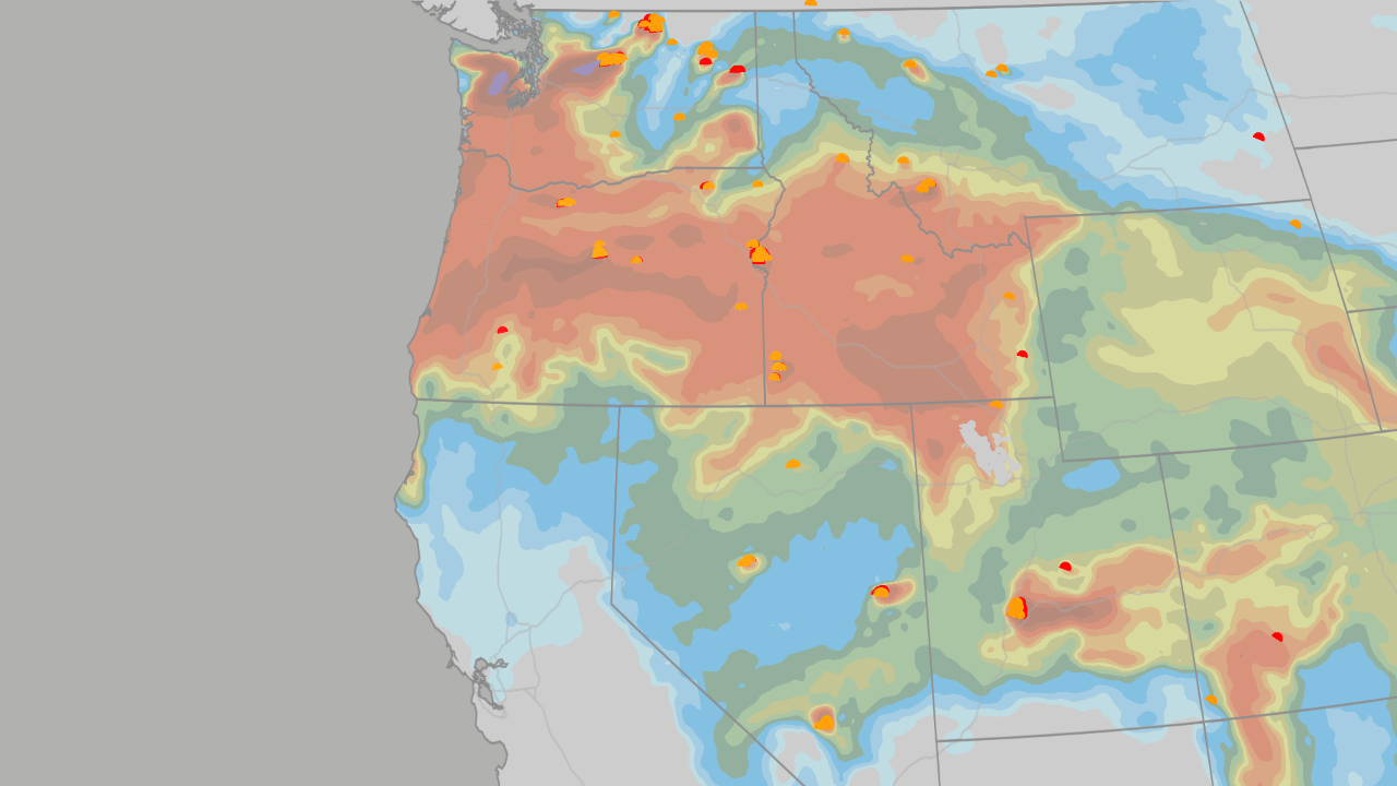
Where Will the Snow Pile Up This Winter? NOAA’s Map Has the Answers
Ever wonder where the snow actually goes each winter? The experts at NOAA (the National Oceanic and Atmospheric Administration) just released their winter snowfall map. It’s built from decades of past winters that look a lot like the one coming up. Think of it as a "cheat sheet" showing where the snow shovels will get the biggest workout—and where they might stay in the garage.
Important Point: This map shows historical averages for this specific weather pattern. It’s not a day-to-day forecast, but it is the best long-range clue we have for where the snow likes to fall.
States That Typically Gain Snow (The "Winners")
When this specific weather pattern sets up, these areas usually see more snow than average.
- California & the Great Basin (Sierra Nevada): The biggest winner in the entire country. The mountains here see the deepest "above average" snow totals.
- The Southwest (Arizona, New Mexico, Utah, Colorado): The high mountains in these states pick up a reliable surplus of snow.
- The Southern Plains (Texas, Oklahoma, Kansas): Snow is rare here normally. But in this pattern, even a "modest gain" means rare snow days become a real possibility.
- The Mid-Atlantic (Virginia, Maryland, West Virginia, North Carolina mountains): The southern Appalachians and lower elevation spots get juiced up by coastal storms.
States That Typically Lose Snow (The "Losers")
These regions usually trend below average for snowfall during this pattern. But read the fine print—Mother Nature always has wild cards.
- Pacific Northwest & Northern Rockies (WA, OR, ID, MT): Usually run below average.
- Upper Midwest & Great Lakes (MN, WI, MI): Trend lighter overall.
- The Wild Card: Lake Effect Snow. Any time bitter Arctic air crosses the relatively warm lake water, the "lake effect machine" fires up and can bury towns in feet of snow, ignoring the "below average" trend.
- The Northeast (NY, PA): Lean below average.
- The Wild Card: Nor’easters. One big coastal storm tracking far enough north can flip an entire season from "dud" to "buried" in just a few days.
Important Point: The scientists behind the map were blunt: Outside that southern "winning" stripe, this pattern "appears to be the great snowfall suppressor over most of North America."
Why This Winter Breaks From the Last Two
The last two winters were weird (in a snowy way) for many spots. This year, the script flips. Here is the head-to-head comparison:
| Region |
The Last Two Winters |
This Winter |
| Great Lakes & Upper Midwest |
Loaded seasons. Record start in 2024 (Erie, PA got 22.6" in one day). |
Lighter lean. Big snow only arrives if Arctic air breaks through. |
| Buffalo & Interior Northeast |
Heavy. Buffalo saw 77.6" just last winter. |
Leaning below average. But every cold outbreak over the lakes is still a snow event. |
| Sierra Nevada |
Huge. 362" at Palisades Tahoe (saved by a 100" March!). |
The deepest surplus zone on the map. Storm track aimed straight here. |
| CO, UT, Four Corners |
Steady. Biggest hit came in a late March storm. |
Reliable surplus. Wet pattern holds strong into spring. |
| TX Panhandle & S. Plains |
Barely a flake. |
Rare snow days go from memory to live possibility. |
| Mid-Atlantic & D.C. |
Long snow droughts with occasional saves. |
Juiced up coastal storms. 2–3 big ones are the norm for a season like this. |
When Does Each State’s "Snow Window" Open?
Snow doesn’t fall all at once. Different regions peak at different times. Here is the calendar:
1. December: The Quiet Opening Act
- Who gets snow? High elevation only.
- Where: The Sierra Nevada, Colorado, and Utah mountains.
- Vibe: Early season base building for ski resorts.
2. January: The Storm Track Hits Full Strength
- Who joins the party? New Mexico, Arizona, and the Southern Plains.
- The Mechanics: Storms arrive behind sharp cold fronts. Temps can drop dozens of degrees in hours, driving blowing snow across the open High Plains.
- East Coast: The first coastal storms start working up the Mid-Atlantic coast.
3. February: The Peak (Prime Time)
- The Sweet Spot: Virginia, Maryland, West Virginia, and the Carolinas’ high country get their best odds.
- The "Juice" Factor: NOAA forecasters note these coastal storms get supercharged by tropical moisture.
- The Stat: An average season like this delivers 2 to 3 big snowstorms—enough to flip the year for Washington D.C. and Baltimore.
4. March & Beyond: The Late Window is Real
- Don’t put the shovel away! The outlook keeps moisture flowing across the southern tier into spring.
- Proof: Last season, March storms buried Colorado’s mountains, and snow was closing passes in the Northern Rockies into May.
- The Pattern: Expect swings between warm and cold stretches, with the stronger half of the season arriving late.
Summary
- The Map: NOAA’s historical map shows a clear divide: The South/Southwest wins; The North/Northwest loses.
- The Big Winners: Sierra Nevada (biggest surplus), Southwest Mountains, Southern Plains (rare snow chances), Mid-Atlantic (coastal storm alley).
- The Big Losers: Pacific NW, Northern Rockies, Upper Midwest, Great Lakes, Northeast (generally lighter).
- The Wild Cards: Lake Effect Snow (Great Lakes) and Nor’easters (Northeast) can ignore the map and bury you anytime.
- The Timeline: Starts high/west in Dec, expands south in Jan, peaks east in Feb, lingers late into Mar/Apr.
- Bottom Line: This is the closest thing to a "snow forecast" we have this far out. Where moisture crosses cold ground, it falls white—and single storms will write the final story.
FAQ
1. Is this a guarantee for my town?
No. This is a probability map based on history, not a forecast for a specific date. It tells you the "odds," not the outcome. A single big storm can change everything.
2. Why is the Great Lakes region a "loser" if they get Lake Effect snow?
The overall pattern favors less snow there (warmer air, storm track further south). However, Lake Effect is a local machine powered by cold wind over warm water. It operates independently of the main storm track, so big localized blasts are still very likely.
3. What does "flip the year" mean for D.C.?
D.C. often gets very little snow in this pattern unless a Nor’easter hits. Since the pattern favors 2–3 big coastal storms, just one or two direct hits can turn a "below average" winter into a "snowmaggedon" winter instantly.
4. Why does the Sierra Nevada do so well this year?
The "storm track" (the highway storms travel on) is aimed directly at California and the Great Basin. They sit in the bullseye for moisture-rich systems coming off the Pacific.
5. When should I book a ski trip?
- Early Season (Dec/Jan): Colorado, Utah, California (Tahoe/Mammoth).
- Peak Season (Feb/Mar): California, Colorado, Utah, New Mexico, Arizona.
- Spring (Mar/Apr): Colorado, Wyoming, Montana (high elevations hold snow late).
 1
1