 11
11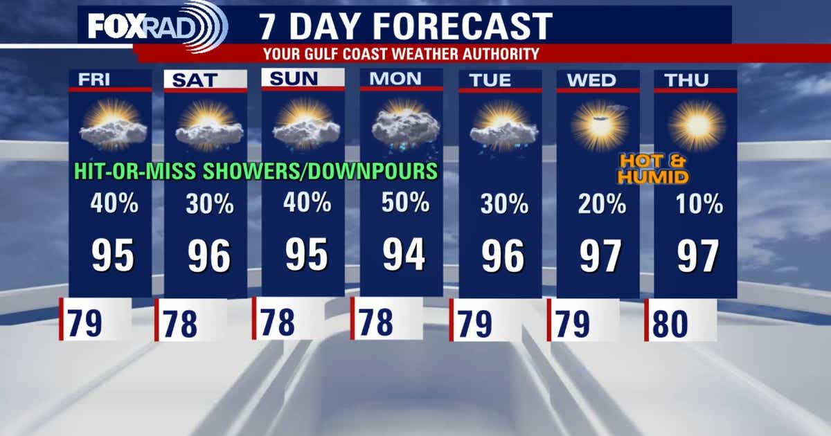
Simple breakdown of what’s happening with the weather in Southeast Texas right now
Gulf moisture has moved back in. Think of the Gulf of Mexico like a giant humidifier. When winds blow from the Gulf toward land, they carry warm, wet air with them. That extra moisture does three things:
Important Point: This isn’t a one-day thing—this pattern sticks around through the weekend and into next week.
Scattered showers and a few thunderstorms are possible every afternoon and early evening. Here’s the simple version of how it works:
Safety reminder: If you hear thunder, you’re close enough to be struck by lightning. Head indoors!
| Measure | What It Means | Feels Like |
|---|---|---|
| Actual temp | 90s°F (around 32–35°C) | Hot |
| Heat index | 100–105°F (38–40°C) | Really hot—your body struggles to cool off |
Why the heat index matters: Sweat cools you by evaporating. High humidity stops evaporation → you stay hot longer. Drink water, take breaks in shade/AC, and check on neighbors and pets.
NOAA (National Oceanic and Atmospheric Administration) just updated their August 2026 hurricane outlook. Here’s the simple takeaway:
Imagine the Pacific Ocean near the equator gets warmer than usual. That warm water changes wind patterns all the way across the Atlantic. Those changed winds rip apart tropical storms before they can grow into hurricanes.
Bottom line: El Niño = fewer Atlantic hurricanes. That’s good news for us.
Meteorologists are tracking two tropical waves—basically, clusters of storminess moving across the tropics.
| Wave Location | Threat to Southeast Texas? | Could It Affect Our Rain? |
|---|---|---|
| Near Florida | No immediate threat | Yes—may boost rain chances by Sunday |
| West coast of Africa | No immediate threat | Too far away to matter right now |
Back-to-school note: The Florida wave might mean wetter weather Monday when some schools start. Keep an umbrella handy!
Stay cool, stay dry, and stay weather-aware!
Scattered means some neighborhoods get drenched while others stay dry—like a game of rain roulette. Widespread means almost everyone gets wet. We’re in “scattered” mode.
If it’s just rain, you’ll get soaked but you’re okay. If there’s lightning or gusty winds, get inside a sturdy building or hard-top car immediately.
It changes the upper-level winds over the Atlantic. Those winds act like scissors, cutting the tops off developing storms so they can’t become hurricanes. Fewer hurricanes = lower risk for the Gulf Coast.
No need to cancel. Just have a Plan B for outdoor events (like a covered pavilion or indoor backup) and check the forecast Friday/Saturday for updates.
Hydrate. With heat indices 100–105°, your body loses fluids fast. Drink water before you’re thirsty, especially if you’re outside.
Source: Your Gulf Coast Weather Authority (FOX 26 Houston)