Pittsburgh: Dangerous Flash Flood Threat Looms Sunday
Weather Alert: Flash Flooding Risk Today, Then Sunshine Returns!
What’s Happening Right Now?
Hey there! The weather team at KDKA has declared today a "First Alert Weather Day." That’s their way of saying: "Hey, pay extra attention to the weather today!"
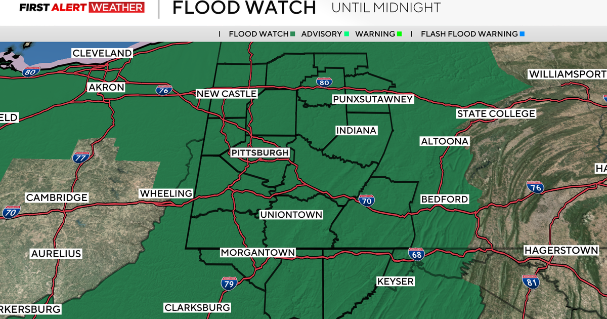
The big concern? Flash flooding this afternoon and evening. A Flood Watch is in effect until midnight.
IMPORTANT: What’s a Flood Watch?
Think of it like a "heads up!" It means conditions are right for flooding to happen, but it’s not happening right this second. It’s time to be prepared, not panic.
Today’s Weather Timeline
This Morning
- A round of thunderstorms already moved through
- Roads might be wet, so take it slow if you’re driving
This Afternoon & Evening (HIGHEST RISK)
- Several more rounds of storms expected
- 1-2 inches of rain likely for most areas
- Some unlucky spots could see even more rain
- Temperatures staying cool — highs won’t even hit 80°F
Overnight
- Flood Watch expires at midnight
- Rain should taper off
Are Severe Storms Expected?
Good news! The severe weather threat is low — only 1 out of 5 on the severity scale.
Severity Scale Explained:
- 1 out of 5 = General thunderstorms (some heavy rain, maybe small hail or gusty winds)
- 5 out of 5 = Widespread dangerous storms (tornadoes, huge hail, damaging winds)
Today is a 1. Just your typical summer storms — but with lots of rain!
Who Needs to Be Extra Careful?
If you check ANY of these boxes, stay extra weather-aware today:
- [ ] You live in a low-lying area
- [ ] Your neighborhood has flooded before
- [ ] You’re near a creek, stream, or river
- [ ] You have a basement that takes on water
- [ ] You’ll be driving during peak storm hours (afternoon/evening)
The Good News: Beautiful Days Ahead!
| Day | Forecast | High Temp | Feels Like |
|---|---|---|---|
| Monday | Mostly sunny, drying out | Low 80s | Comfortable! |
| Tuesday | Sunshine continues | Low 80s | Low humidity = nice! |
| Wed-Fri | Scattered storms return | Low-mid 80s | More humid |
Monday and Tuesday look fantastic — perfect for outdoor plans!
Your Action Plan: 5 Simple Steps
- Check the radar before heading out this afternoon
- Never drive through flooded roads — "Turn Around, Don’t Drown!"
- Move cars to higher ground if you’re in a flood-prone spot
- Keep phone charged and weather alerts ON
- Plan indoor activities for this afternoon/evening just in case
Summary
| Today | Mon-Tue | Late Week |
|---|---|---|
| Flood Watch until midnight | Sunny & pleasant | Storms return |
| Multiple storm rounds | Low 80s, low humidity | Low-mid 80s |
| Highs below 80°F | Great outdoor days | Keep umbrella handy |
| Low severe threat (1/5) |
Bottom line: Today’s the wet, watchful day. Monday and Tuesday are your reward — get outside and enjoy them!
Frequently Asked Questions
"What’s the difference between a Flood Watch and a Flood Warning?"
Great question! A Watch means "be ready — flooding could happen." A Warning means "take action — flooding is happening or about to happen." Today we’re at the Watch stage.
"How much rain is 1-2 inches really?"
Picture this: 1 inch of rain = a heavy, steady downpour for about 2-3 hours. 2 inches = that same rain for 4-6 hours. It’s enough to overwhelm storm drains and flood low spots.
"Should I cancel my evening plans?"
If they’re outdoors or require driving through flood-prone areas — yes, have a backup plan. If you’re staying put indoors — you’re fine! Just keep an eye on alerts.
"Will my basement flood?"
If it usually stays dry, probably not. If it sometimes gets damp or has flooded before — move valuables off the floor now and check your sump pump!
"When will the Flood Watch be lifted?"
The Watch expires at midnight tonight. But even after it’s lifted, rivers and creeks might stay high for another day. Stay cautious near waterways tomorrow morning.
Stay safe, stay dry, and enjoy those beautiful Monday-Tuesday vibes coming your way!
Source: KDKA Weather Center | Forecast Date: August 2, 2026