Bug Fire Forces Evacuations in Nevada and California: What You Need to Know
What Happened?
On Saturday, August 8, 2026, a wildfire named the Bug Fire started burning near Highway 395, south of Hallelujah Junction. The fire has already burned more than 2,400 acres—that’s about the size of 1,800 football fields put together!
Key facts right now:
- Zero containment – firefighters haven’t been able to put a line around the fire yet
- Location – Right along the Nevada/California border off Highway 395
- Multiple counties affected – Washoe County (NV), Lassen County (CA), and Sierra County (CA)
- Sources – Watch Duty, WildCAD, Sierra County Sheriff’s Office, and California Highway Patrol (CHP)
Where Is the Fire Burning?
The Bug Fire is burning in a rural area south of Hallelujah Junction along Highway 395. This is a mountainous region near the Nevada-California state line, with several small communities nearby.
Who Needs to Evacuate Right Now?
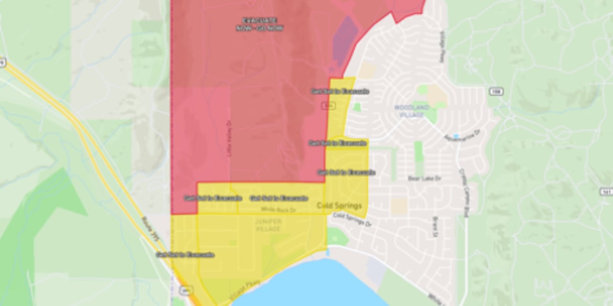
EVACUATION ORDERS (Leave Immediately!)
An Evacuation Order means danger is imminent. You must leave NOW.
Washoe County, Nevada:
- Cold Springs
- Canyon Hills
- White Lake
Lassen County, California:
- Zone LAS-671-B – Mandatory evacuation order
EVACUATION WARNINGS (Be Ready to Leave)
An Evacuation Warning means danger is possible. Pack your bags and be prepared to go at a moment’s notice.
Lassen County, California:
- Zone LAS-671-A – Evacuation warning
Sierra County, California:
- Zone SIE-E025 – East of Highway 395 near the state line
IMPORTANT: Know Your Zone!
Many counties now use zone numbers (like LAS-671-B) instead of just neighborhood names. Look up your zone before an emergency at your county’s emergency management website.
Where Can People Go for Safety?
Official Emergency Shelter
North Valleys Library
1075 N Hills Boulevard, Reno, NV
Open now for anyone displaced by the fire
Don’t Forget Your Pets!
- Bring pet food, medications, and carriers
- Most shelters accept pets, but call ahead if you have large animals
- Have a plan for livestock if you’re in a rural area
Road Updates
Highway 395 Status
- Northbound US-395: OPEN to one-way traffic near the state line
- Southbound lanes: Check CHP updates before traveling
- Expect delays – fire trucks and emergency vehicles are using the highway
If you’re driving through the area:
Keep windows rolled up, use recirculated air, and drive slowly. Never stop to take photos—this blocks emergency vehicles!
How to Stay Informed (Official Maps & Links)
Real-Time Evacuation Maps
Other Ways to Stay Updated
- Sign up for emergency alerts – Text your zip code to 888-777 or visit your county’s emergency management website
- Follow official accounts – @WashoeSheriff, @LassenCountyOES, @SierraCountySheriff on social media
- Watch Duty app – Free app showing real-time fire info (mentioned as a source in this report)
- Local radio – Keep a battery-powered radio handy in case power goes out
Your Emergency "Go Bag" Checklist
If you’re in a warning zone or just want to be prepared, pack these now:
Essentials (Grab First)
- [ ] People and pets first!
- [ ] Phone + charger + portable battery pack
- [ ] ID, insurance papers, important documents (or photos of them on phone)
- [ ] Medications (7-day supply)
- [ ] Cash and credit cards
Basics
- [ ] Change of clothes + sturdy shoes
- [ ] Jacket/layers (mountain weather changes fast)
- [ ] Flashlight or headlamp + extra batteries
- [ ] Water (1 gallon per person per day) + snacks
For Pets
- [ ] Food, water, bowls
- [ ] Leash, carrier, litter box
- [ ] Vet records, medications
- [ ] Photo of you with your pet (proves ownership)
If Time Allows
- [ ] Laptop/backup drives
- [ ] Irreplaceable photos/keepsakes
- [ ] Fireproof safe (if you have one)
Summary
The Bug Fire is an active wildfire burning 2,400+ acres near the Nevada-California border with 0% containment as of August 8, 2026.
Right now:
- Mandatory evacuations for parts of Cold Springs, Canyon Hills, White Lake (Washoe County) and Zone LAS-671-B (Lassen County)
- Evacuation warnings for Zone LAS-671-A (Lassen) and Zone SIE-E025 (Sierra)
- Shelter open at North Valleys Library in Reno
- Northbound Highway 395 open (one-way only)
- Check your zone on official maps: Genasys (CA) or Perimeter (NV)
Most important: If you get an evacuation order, leave immediately. Stuff can be replaced. You cannot.
FAQ: Your Questions Answered
What’s the difference between an Evacuation Order and an Evacuation Warning?
Evacuation Order = LEAVE NOW. Life-threatening danger is happening or about to happen. Staying puts you and first responders at risk.
Evacuation Warning = GET READY. Danger is possible. Pack your car, gather your family/pets, and be prepared to leave within minutes.
How do I find out which zone I live in?
Visit your county’s emergency management website before an emergency:
- Washoe County: WashoeCounty.gov/emergency
- Lassen County: LassenCounty.org/OES
- Sierra County: SierraCounty.ca.gov/emergency
Or use the map links above and type in your address.
What if I don’t have a car or can’t drive?
Call 211 (or your county’s non-emergency line) RIGHT NOW. Many counties have transport assistance for seniors, people with disabilities, and those without vehicles. Don’t wait until the last minute!
Can I go back home to check on things during a warning or order?
NO. During an Order, it’s illegal to enter. During a Warning, it’s strongly discouraged. Roads need to stay clear for fire engines and evacuating neighbors. You also risk getting trapped if the fire shifts suddenly.
Where can I find information about my animals/livestock?
- Small pets: Bring to the shelter with you (North Valleys Library accepts them)
- Large animals/livestock: Contact Washoe County Regional Animal Services (775-322-3647) or Lassen County Animal Control for temporary boarding locations
- Never turn animals loose – they panic and block roads
Article based on official reports from KOLO, Watch Duty, WildCAD, Sierra County Sheriff’s Office, and California Highway Patrol. Copyright 2026 KOLO. All rights reserved.
Stay safe, stay informed, and look out for your neighbors!
 1
1