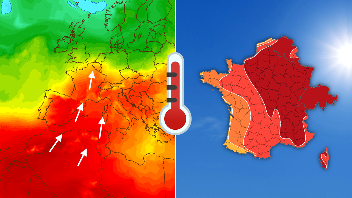
Canicule : 48h Infernales avant le Grand Soulagement !
Heatwave Forecast for Early August 2026 – What You Need to Know
Important: This article explains the upcoming hot spell in simple terms. It is not an official weather warning. Always check your local meteorological service for the latest alerts.
1. Quick Overview
- When? Sunday 2 August → Monday 3 August → Tuesday 4 August (and the rest of the week).
- Where? Most of France, plus parts of Belgium, Switzerland, and the western Mediterranean coast.
- What? Temperatures climbing into the mid‑30 °C (mid‑90 °F) range, then a gradual cool‑down after Monday evening thunderstorms.
2. Day‑by‑Day Breakdown
Sunday 2 August – The First Peak
| Region | Expected High (°C) | Expected High (°F) | How It Feels |
|---|---|---|---|
| Pays de la Loire → North‑East France & Switzerland | 31‑34 | 88‑93 | Warm, sunny |
| Southern half of France (Occitanie, Provence, etc.) | 34‑37 | 93‑99 | Very hot |
| Coast of the English Channel & North Sea | 25‑28 | 77‑82 | Comfortable |
All areas enjoy clear skies and strong sunshine.
Monday 3 August – Heat Moves North‑East
| Region | Expected High (°C) | Expected High (°F) | Notes |
|---|---|---|---|
| Provence → Paris Basin → Belgium & Switzerland | 34‑37 | 93‑99 | Peak heat for the day |
| Occitanie → West Normandy | 31‑34 | 88‑93 | Still hot, but a bit lower |
| Atlantic coast (Brittany, Normandy coast) | 25‑28 | 77‑82 | Noticeable relief |
| Evening | — | — | Strong thunderstorms from the Pyrenees up to central France |
Tuesday 4 August – The Cool‑Down Begins
| Region | Expected High (°C) | Expected High (°F) | Trend |
|---|---|---|---|
| Mediterranean → Île‑de‑France → Belgium | 31‑34 | 88‑93 | Still warm |
| Alsace → Northern Switzerland | 34‑37 | 93‑99 | Last pockets of intense heat |
| Western half of France (incl. Brittany) | 28‑31 | 82‑88 | More breathable |
| Coastal Brittany & Channel coast | 25‑28 (or < 25) | 77‑82 (or < 77) | Comfortable |
After Monday’s storms, a cooler air mass pushes in from the west.
Rest of the Week
- Temperatures keep dropping day by day.
- The Mediterranean coast may stay a few degrees warmer than the rest of the country, but the overall trend is toward comfortable summer highs (mid‑20s °C / high‑70s °F).
3. What to Do During the Heat (Simple Steps)
- Stay Hydrated – Drink water regularly, even if you don’t feel thirsty.
- Seek Shade / Cool Spaces – Spend the hottest hours (12 pm‑4 pm) indoors or under trees.
- Limit Physical Effort – Postpone heavy exercise to early morning or evening.
- Protect Skin – Wear a wide‑brim hat, sunglasses, and sunscreen (SPF 30+).
- Check on Vulnerable People – Elderly, children, and anyone with health issues need extra care.
- Watch for Storms (Monday Evening) – If thunderstorms arrive, stay indoors, avoid open fields, and unplug sensitive electronics.
4. Key Takeaways (Callout)
QUICK RECAP
- Sunday & Monday: Very hot (up to 37 °C / 99 °F) over most of France, Belgium, Switzerland.
- Monday night: Strong thunderstorms → cooler air arrives.
- Tuesday onward: Temperatures fall steadily; only the Mediterranean stays a bit warmer.
- Stay safe: Hydrate, stay cool, and keep an eye on local alerts.
5. Summary
A short but intense heatwave will hit France and neighbouring countries on 2‑3 August. The hottest temperatures (34‑37 °C) will cover a large swath from the Mediterranean up to the Paris region and into Belgium and Switzerland. Monday evening brings strong thunderstorms, which usher in a cooler air mass. By Tuesday, most areas feel noticeably more comfortable, and the cooling trend continues through the week.
Bottom line: Enjoy the sunshine, but take the usual heat‑wave precautions—especially on Sunday and Monday.
6. FAQ
| # | Question | Answer |
|---|---|---|
| 1 | Why does the heat move north‑east on Monday? | A high‑pressure system over the continent pushes warm air toward the north‑east, while a low‑pressure trough from the Atlantic brings cooler air later in the day. |
| 2 | Are the thunderstorms dangerous? | They can bring heavy rain, gusty winds, and lightning. Stay indoors, avoid tall objects, and unplug electronics if a storm is close. |
| 3 | Will the heat return later in August? | This forecast only covers the first week. Summer heatwaves can re‑appear, so keep checking daily forecasts. |
| 4 | What’s the difference between “31‑34 °C” and “34‑37 °C”? | The first range is hot; the second is very hot and can increase the risk of heat‑related illness if you’re not careful. |
| 5 | How can I protect my pets? | Provide plenty of fresh water, keep them in shaded or air‑conditioned areas, and never leave them in a parked car. |
Stay cool, stay safe, and enjoy the summer!