Popular Posts

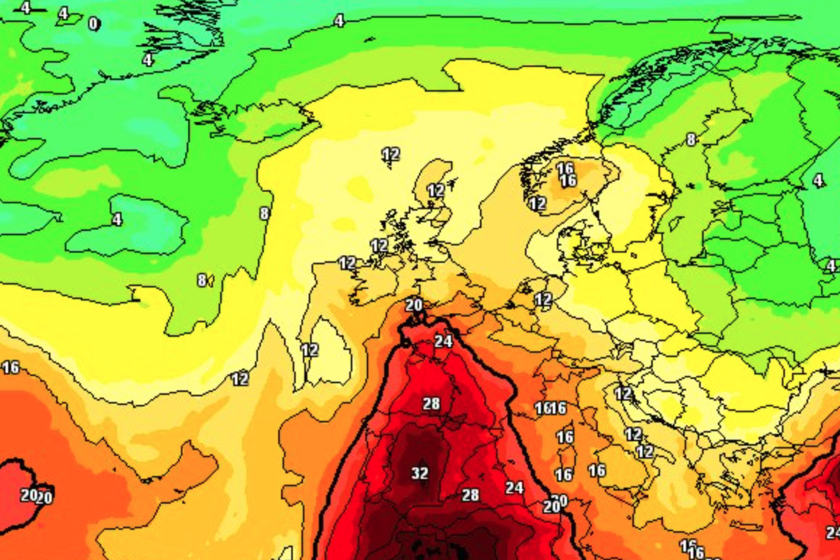
Sonntag 34 Grad – warum die neue Woche noch heißer wird

Sonntag 34 Grad – warum die neue Woche noch heißer wird

Germany’s Super Sunny and Hot Weekend – Weather Explained Like You’re 5

What’s the Weather Like on Sunday?

Imagine a day where the sun is out almost all the time and the sky is mostly blue. That’s this Sunday in Germany!

The German Weather Service (called DWD) tells us:

  • In the southwest it can get as hot as 34°C (that’s really warm!).
  • In the south about 32°C.
  • In the capital Berlin and the middle of Germany about 30°C.
  • At the coast (where the sea is) it’s cooler: only 20 to 26°C.

So, most places are like a warm summer playground, but the beach is a bit fresher.

Why Is It So Hot?

We asked weather expert Dominik Jung (he’s a trained meteorologist – a weather scientist). He says:

  • A big “high‑pressure area” is sitting on top of central Europe.
    Think of high pressure like a heavy invisible lid that pushes clouds away and keeps the sky clear. This one used to be near the Azores islands, so it’s called the “former Azores high.”
  • Because of this lid, the sun can shine as long as possible – from sunrise to sunset!
  • The wind is just gently blowing from the north (weak to moderate).

But it’s not 100% cloud‑free:

  • In the northeast, far east, and far southwest, some puffy clouds (scientists call them cumulus clouds) might pop up in the afternoon.
  • In the eastern parts, a quick hot rain storm (heat thunderstorm) might happen, but that’s rare.

Important: Even though it’s sunny and nice, the heat is serious! Read the next part.

Warnings: Heat, Forest Fires, and Sunburn

Mr. Jung gives us some grown‑up warnings that we should all listen to:

  • Forest fire danger: Because it has been so dry, especially in the southwest, forests can catch fire easily. Normally by now in July, we should have had about 100% of the usual rain, but we’ve only had 15%!
  • Strong sun rays (UV): The sun is extra strong. Try to stay out of the sun around midday.
  • Drink up! You should drink plenty of water or tea so your body doesn’t get thirsty and tired.

Important: Avoid the midday sun, drink water, and don’t play with fire in forests!

The Heat Wave Keeps Going – Next Week Gets Even Hotter

The hot days don’t stop on Sunday. The new week brings even higher numbers. Let’s look at the plan step by step:

  1. Monday: North = 26°C, Middle of Germany = 36°C, South = 22°C.
  2. Tuesday: North = 28°C, Middle = 36°C, South = 32°C.
  3. Wednesday: North = 30°C, Middle = 36°C, South = 33°C.
  4. Thursday (added by another expert): In the southwest, it might reach 39°C! After that, some storms may bring a tiny cool‑down.

Another expert, Dr. Karsten Brandt (a climate scientist), says the heat wave will not go away easily. He expects up to 39°C on Wednesday and Thursday in the southwest, then thunderstorms and maybe a bit of cooling.

What the Smart Weather People Say

We have two experts in the story:

  • Dominik Jung – He is a graduated meteorologist (Diplom‑Meteorologe) and climate expert at the online portal and app wetter.net. He is managing director at Q‑met and runs a YouTube channel where he shows the daily weather. He says:

    • No real “big cool change” is coming soon.
    • From about Thursday/Friday, the air gets sticky (muggy) and there may be strong storms with heavy rain, hail (ice balls), and wind gusts.
    • The weekend (from the 18th) may have showers and storms, but temperatures stay between 28 and 34°C – still summery, just more humid and stormy.
  • Dr. Karsten Brandt – He earned a doctorate (PhD) in natural sciences with a focus on climatology at the University of Duisburg‑Essen. He wrote several weather books and is founder and managing director of Donnerwetter.de. He agrees it stays hot, with those very high 39°C days mid‑week.

Summary

To sum it up simply:

  • Sunday is sunny and hot (up to 34°C), but coasts are cooler.
  • A big high‑pressure system acts like a clear‑sky lid.
  • Be careful: forests are dry, sun is strong, drink water.
  • Monday to Wednesday get even hotter (up to 36°C in the middle, 39°C southwest by Thu).
  • After Thursday, storms may come but it stays warm (28–34°C).

Enjoy the sun safely!

FAQ (Frequently Asked Questions)

1. What is a “high‑pressure area” in kid words?
It’s like a heavy blanket of air that pushes down on the land. It keeps rain clouds away, so we get lots of sun and heat.

2. Why are forests in danger right now?
Because it barely rained in July (only 15% of normal), the trees and ground are very dry. A small spark could start a big fire.

3. How can I stay safe in this heat?
Drink plenty of water or tea, play in the shade at midday, and put on sun protection. If you go to a forest, don’t light any fires.

4. Will it suddenly become cold again?
No. Experts say no dramatic temperature drop. It will stay warm (28–34°C) even when storms come, just a bit more humid and stormy.

5. What is a “heat thunderstorm”?
It’s a short rain or lightning storm that happens on very hot days when puffy clouds build up and release their energy.

Leave a Reply

Your email address will not be published. Required fields are marked *