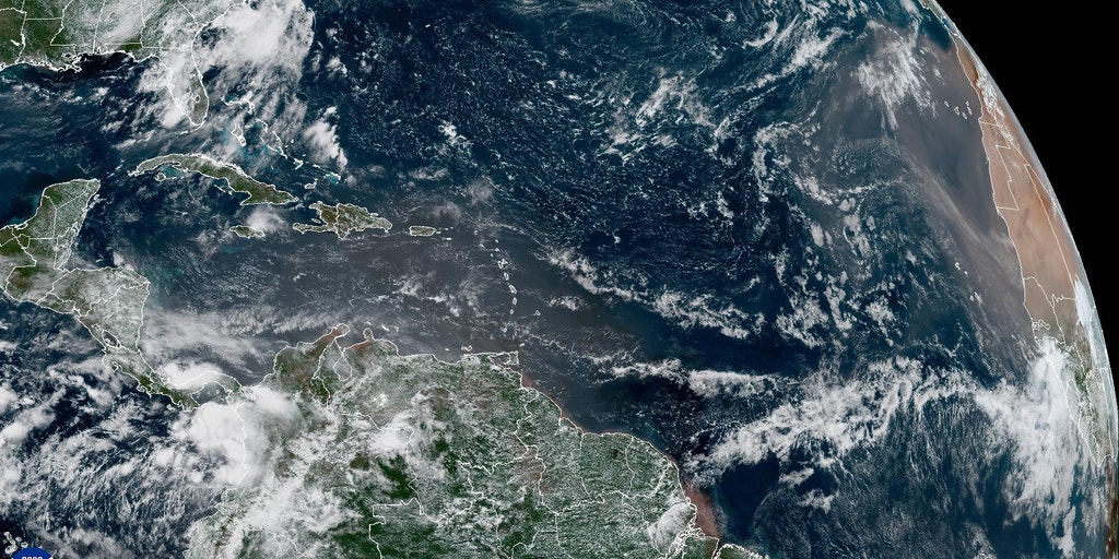
Why the Atlantic Is a ‘Graveyard’ for Storms Despite Nonstop African Waves
Why the Atlantic Hurricane Season Is Taking a Surprising Nap (And When It Might Wake Up)
TL;DR: Even though we’re heading into the busiest part of hurricane season, the Atlantic is eerily quiet. A super-strong El Niño, massive Saharan dust clouds, and hostile winds are teaming up to stop storms from forming. But experts say don’t let your guard down—things could change fast.
What’s Happening Right Now?
Imagine the Atlantic Ocean as a giant storm kitchen. Usually, by early August, the oven is hot and tropical storms are baking left and right. But this year? The kitchen is strangely empty.
- Only two named storms so far: Arthur (June) and Bertha (July).
- Peak season is coming (September), but the National Hurricane Center sees "crickets"—zero activity across the Atlantic, Caribbean, and Gulf of Mexico.
- The third storm (which would be named Cristobal) typically forms by August 3. We’re past that date with nothing brewing.
Important: Hurricane season runs June 1 – November 30. We’re only halfway through.
Where Do Hurricanes Come From? (The "Seed" Explanation)
Think of tropical waves like baby storm seeds. They roll off the coast of Africa every 2–4 days from April to November—about 60 to 65 per year on average.
These waves travel west into the Main Development Region (MDR)—a stretch of warm ocean between Africa and the Caribbean. If conditions are right, they grow into tropical storms or hurricanes.
ELI5 Analogy: Tropical waves are like popcorn kernels. The MDR is the hot pan. But right now? The heat is off.
The Three "Storm Stoppers" Blocking Development
Three big bullies are keeping the Atlantic quiet:
1. El Niño – The Pacific Puppet Master
- What it is: A natural climate pattern where the central/eastern Pacific Ocean gets unusually warm.
- What it does: It sends strong upper-level winds across the Atlantic that chop the tops off developing storms (this is called wind shear).
- Current status: Strengthening fast. Could become a "Super El Niño"—one of the strongest ever—by September.
2. Saharan Dust – The Dry, Dirty Blanket
- Massive plumes of dry, dusty air blow off the Sahara Desert.
- This air is super dry and stable—the exact opposite of what storms need (moisture + rising air).
- It’s blanketing the tropics right now, suffocating any baby storms.
3. Strong Wind Shear – The Storm Shredder
- Winds at different altitudes blowing at different speeds/directions.
- Tears storms apart before they can organize.
- Not expected to let up for at least the next 7 days.
Callout: All three are active at the same time. That’s rare—and it’s why the Atlantic is on "pause."
But Wait… The Water Is Warm!
Here’s the twist: Ocean temperatures are slightly above average. Warm water is hurricane fuel. So if a storm could somehow dodge the dust and shear, it could explode.
- One possibility: A northern piece of a tropical wave might sneak north of the Caribbean, avoiding the worst wind shear.
- But it would still have to survive the Saharan dust layer.
- Bottom line: Possible, but not likely right now.
The Pacific Is Partying While the Atlantic Naps
While the Atlantic is quiet, the Eastern Pacific is hyper-active.
- Why? El Niño fuels storms there—opposite effect!
- Multiple hurricanes (like Genevieve) have already formed.
- This seesaw is classic El Niño behavior.
What’s Next? (The Crystal Ball)
Next Week (Early August)
- Computer models hint at another tropical wave trying to organize Monday–Wednesday.
- But: It faces the same triple threat (shear, dust, El Niño winds).
- Status: "Only something to watch" — FOX Forecast Center.
Mid-August
- Updated ENSO forecast drops (that’s the official El Niño/La Niña outlook).
- Will tell us how strong El Niño gets this fall.
September (Peak Season)
- El Niño likely at "Super" strength.
- Historically, strong El Niño = fewer Atlantic hurricanes.
- But: Not zero. Some of history’s worst storms happened during El Niño years (e.g., Andrew 1992, Michael 2018).
Key Takeaway: "Quiet now ≠ quiet later." Stay prepared.
Your Hurricane Season Checklist (Even in a "Quiet" Year)
- Know your zone – Are you in an evacuation zone? Find out now.
- Build a kit – Water, food, meds, flashlights, batteries, cash, docs (3–7 days’ worth).
- Make a plan – Where will you go? How will family connect? Pets included?
- Check insurance – Flood damage isn’t covered by standard homeowners policies.
- Stay informed – Follow NHC (hurricanes.gov), local NWS, and trusted meteorologists (like FOX Weather’s Bryan Norcross & Stephen Morgan).
- Don’t trust the "cone" alone – Impacts (rain, wind, surge) happen far outside the forecast cone.
Summary
| Factor | Status | Effect on Atlantic Storms |
|---|---|---|
| El Niño | Strengthening → "Super" likely | Strong suppression (high wind shear) |
| Saharan Dust | Widespread, thick | Suffocates moisture – stops storm seeds |
| Wind Shear | Strong, persistent | Shreds developing systems |
| Ocean Heat | Slightly above average | Fuel available – if a storm forms |
| Tropical Waves | Rolling off Africa normally | Plenty of seeds – but blocked from growing |
| Next Watch | Early next week (Mon–Wed) | Low odds, but monitored |
Bottom line: The Atlantic is in a forced timeout. But the clock is still ticking toward peak season. Prepare now—don’t wait for the wake-up call.
FAQ: Your Burning Questions, Answered Simply
1. Does "quiet July" mean a quiet whole season?
Nope. 1992 had a quiet start—then Hurricane Andrew (Cat 5) hit in late August. Early activity ≠ total season activity.
2. What is the "Main Development Region" (MDR)?
It’s the tropical Atlantic belt between Africa and the Caribbean (roughly 10°N–20°N). Most major hurricanes are born here. Think of it as the hurricane nursery.
3. How does El Niño help the Pacific but hurt the Atlantic?
El Niño warms the central/eastern Pacific → more thunderstorms there → rising air → upper-level winds flow eastward into the Atlantic → increased wind shear over the Atlantic. Same cause, opposite effects.
4. Can Saharan dust reach the U.S.?
Yes! It often makes it to Florida, Texas, the Gulf Coast, even the Midwest. It creates hazy skies, vivid sunsets, and can trigger asthma/allergies. But it also suppresses storms—a mixed bag.
5. When should I really start paying attention?
Now. But ramp up vigilance mid-August through October. That’s the climatological peak. Even in strong El Niño years, the most dangerous storms often form in September–October.
Stay Tuned: Follow FOX Weather for daily tropical updates, expert analysis from Bryan Norcross & Stephen Morgan, and the latest model trends. The nap won’t last forever.