Chicago Weather Alert: Multiple Rounds of Storms Expected Through the Week
What’s Happening Right Now?
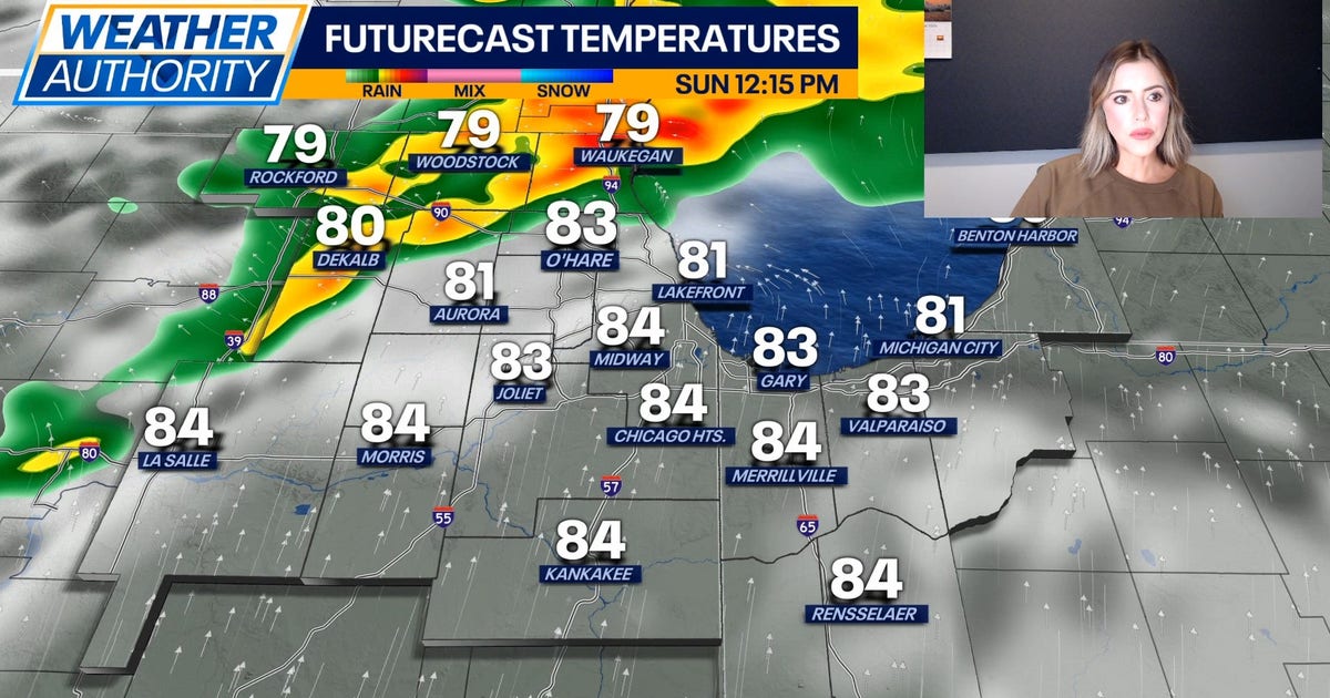
Fox Chicago Meteorologist Kaitlin Cody is tracking a busy weather pattern for the Chicago area starting Sunday, August 9, 2026. Think of it like Mother Nature setting up a series of "storm rounds" – one after another – through much of the workweek.
IMPORTANT ALERTS ACTIVE RIGHT NOW
- Severe Thunderstorm Watch – Lake & McHenry Counties until 2:00 PM Sunday
- Severe Thunderstorm Warning – Parts of Chicago, Cook, DuPage & Kendall Counties until 2:00 PM Sunday
- Ground Stop at O’Hare Airport – Flights paused until 1:30 PM Sunday per FAA
What to Expect Today (Sunday)
Two Main Storm Rounds
- Midday to Afternoon – First batch of storms moving through
- Late Afternoon into Tonight – Second round, higher flood risk
All Hazards Possible Today
- Lightning – Stay indoors when thunder roars!
- Damaging Winds – Can knock down trees & power lines
- Large Hail – Protect vehicles if possible
- Flash Flooding – Biggest concern tonight – never drive through flooded roads!
Today’s Numbers
- High Temperature: Mid 80s (°F)
- Sky: Increasing clouds throughout the day
The Week Ahead – Storm Chances Continue
| Day |
Conditions |
High Temp |
Storm Chance? |
| Monday |
Partly sunny |
Mid 80s |
Yes – afternoon/evening |
| Tuesday |
Mostly cloudy |
Mid 80s |
Yes – strong to severe possible |
| Wednesday |
Mostly cloudy |
Mid 80s |
Yes – rain & storms likely |
| Thursday |
Mostly cloudy |
Upper 70s–80 |
Chance for rain |
| Friday |
Mostly sunny |
Upper 70s |
Low (finally a break!) |
| Saturday |
Partly sunny |
Upper 70s |
Returns Friday night/Saturday |
KEY TAKEAWAY: Keep your umbrella handy and weather alerts ON through Thursday. Friday looks like the first really nice day!
How to Stay Safe – Simple Steps
- Enable Weather Alerts on your phone (Wireless Emergency Alerts + weather app)
- Check Forecasts before heading out – especially for afternoon/evening plans
- Secure Outdoor Items – patio furniture, trampolines, trash bins
- Park Smart – garage or covered parking if hail threatens
- Never Drive Through Flooded Roads – "Turn Around, Don’t Drown!" (just 6 inches of moving water can knock you down; 1 foot floats a car)
- Have a Safe Spot – interior room, lowest level, away from windows
- Charge Devices – in case power goes out
Quick Summary
- Today (Sun): Two storm rounds, severe warnings active, O’Hare ground stop until 1:30 PM
- Main Threats: All severe hazards possible; flooding biggest risk tonight
- This Week: Storm chances Mon–Thu, highs in 80s
- Good News: Friday looks mostly sunny – first real break!
- Stay Alert: Multiple watches/warnings likely each afternoon/evening
Frequently Asked Questions
Q: What’s the difference between a Watch and a Warning?
A: Think of it like baking cookies:
- Watch = "Ingredients are ready" – conditions could produce severe weather. Be prepared.
- Warning = "Cookies are in the oven" – severe weather is happening or imminent. Take action NOW!
Q: Why is flooding the "biggest concern tonight"?
A: Storms training (moving over same areas) + nighttime = harder to see flood waters + slower drainage. Never walk or drive through standing water – you can’t judge depth!
Q: What does "Ground Stop" at O’Hare mean for my flight?
A: No planes take off or land until lifted (1:30 PM today). Check with your airline – delays likely even after it lifts. Sign up for flight alerts!
Q: Are these storms unusual for August in Chicago?
A: Not at all! Late summer often brings humid air + jet stream energy = frequent storm clusters. The multi-day pattern is notable but not rare.
Q: Should I cancel outdoor plans for Monday–Thursday?
A: Have a Plan B (indoor backup). Mornings often start okay – storms typically fire afternoon/evening. Monitor radar & alerts hourly if you must be outside.
Stay safe, Chicago! Keep watching Fox 32 for updates from Meteorologist Kaitlin Cody and the weather team.
 1
1