Severe Storms Hit New York City Area: What You Need to Know
What’s Happening Right Now
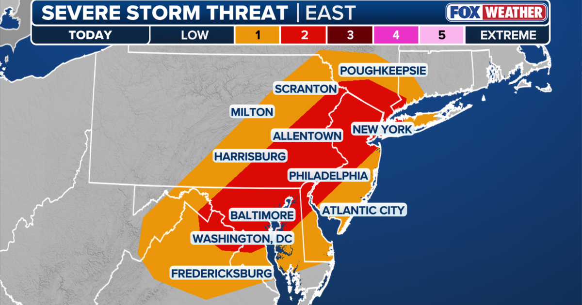
IMPORTANT ALERT: New York City and nearby areas are under multiple weather warnings Friday evening. Stay indoors if possible and avoid travel unless absolutely necessary.
Current Warnings in Effect
| Warning Type |
Areas Affected |
Until |
| Severe Thunderstorm Warning |
Manhattan, Brooklyn, Queens |
6:30 p.m. |
| Severe Thunderstorm Warning |
Bergen & Passaic Counties (NJ), Rockland County (NY) |
8:45 p.m. |
| Flash Flood Warning |
New York City and surrounding area |
9:00 p.m. |
| Heat Advisory |
Entire region |
8:00 p.m. |
| Air Quality Alert |
Entire region |
11:00 p.m. |
What These Warnings Mean (ELI5 Style)
Severe Thunderstorm Warning
Think of this like: "Big, angry clouds that can hurt you."
- Strong winds that can knock down trees and power lines
- Large hail (ice balls falling from sky)
- Dangerous lightning
- What to do: Stay inside, away from windows
Flash Flood Warning
Think of this like: "Water rising super fast with no warning."
- Roads can become rivers in minutes
- Basements can fill with water
- Never drive through flooded roads — cars float in just 12 inches of water!
Heat Advisory
Think of this like: "Outside feels like a hot oven."
- Temperature + humidity = feels like 95°F
- Your body has trouble cooling itself
- Drink water, stay in AC, check on neighbors
Air Quality Alert
Think of this like: "The air has invisible yucky stuff in it."
- High ozone (smog) from heat + pollution
- Harder to breathe, especially for kids, elderly, asthma sufferers
- AQI was 55 at noon (moderate), could reach unhealthy levels later
Storm Timeline: When Will It Be Worst?
- After 2:00 p.m. — Storms start forming in Tri-State Area
- 4:00 p.m. onward — Highest chance of severe weather (50-60% probability)
- Evening hours — Greatest risk for damaging winds and flash flooding
- Overnight — Storms should weaken, but flooding danger continues
Risk Level: "Level 2 out of 5" — This means "scattered severe storms possible" — larger areas could be impacted, not just isolated spots.
Transportation Disruptions
NJ Transit Rail Service Suspended
Reason: "Weather-related issues" including a fallen tree on tracks near Newark
Lines Affected:
- Morris, Essex & Gladstone Branch — Closed both directions between Summit and Newark Broad Street Station
- Montclair-Boonton Line — Service suspended both directions between Hoboken and Hackettstown
Tip: Check NJ Transit website or app for bus alternatives and updates.
Why Is This Happening? (The "Dig Deeper" Part)
The Perfect Storm Recipe:
- Long heat wave — Days of hot, humid weather
- Moisture in the air — Like a soaked sponge
- Trigger — A weather front moving through
- Result — Explosive storm development
Meteorologist Mike Woods (FOX 5 NY) explains: The heat and humidity have been building for days. When a front arrives, it’s like popping a shaken soda bottle — storms erupt quickly.
How to Stay Safe: Step-by-Step
Right Now (During Warnings)
- Go indoors immediately — Sturdy building, not a shed or car
- Stay away from windows — Flying debris breaks glass
- Charge phones/devices — Power outages likely
- Have flashlights ready — Not candles (fire risk)
- Monitor alerts — Weather radio, phone alerts, FOX 5 NY
If You’re Driving
- Pull over safely — Parking lot, not under trees
- Never drive through flooded roads — Turn around, don’t drown
- Watch for downed wires — Assume ALL wires are live
After the Storm
- Wait for "all clear" — Don’t go out until warnings expire
- Check for damage — Roof, trees, basement
- Report outages — Call your utility company
- Check on neighbors — Especially elderly or vulnerable
Summary
| Key Point |
Details |
| Main Threat |
Damaging winds, flash flooding, large hail |
| Worst Time |
4:00 p.m. – 9:00 p.m. Friday |
| Areas at Risk |
NYC (5 boroughs), North NJ, Lower Hudson Valley |
| Heat Factor |
Heat index ~95°F, air quality worsening |
| Transit Impact |
NJ Transit rail lines suspended |
| Source |
FOX 5 NY Weather Team / Meteorologist Mike Woods / National Weather Service |
Bottom line: This is a serious but manageable situation if you take precautions. The storms will pass. Stay informed, stay inside, stay safe.
FAQ: Your Questions Answered
"What does ‘Level 2 risk’ mean exactly?"
A: It’s a 2 out of 5 on the severe weather scale. Think: "Be prepared, storms could be strong." Level 1 = marginal, Level 3 = enhanced, Level 4 = moderate, Level 5 = high. Level 2 means scattered severe storms possible — not everyone gets hit, but storms that form could be dangerous.
"Should I pick up my kids from after-school activities?"
A: Yes, if safe to do so before 4 p.m. After 4 p.m., shelter in place at their location. Most schools/camps have severe weather plans. Call them first.
"My basement flooded last time. What should I do differently?"
A:
- Move valuables up high now (before water comes)
- Check sump pump is working
- Have wet/dry vac ready
- Know how to shut off electricity safely (don’t stand in water!)
"Is climate change making this worse?"
A: Scientists say yes. Warmer air holds more moisture = heavier downpours. Heat waves are longer and more intense. This storm fits the pattern.
"Where do I get the latest updates?"
A:
- FOX 5 NY (TV, app, website)
- National Weather Service weather.gov
- NYC Notify — Text NOTIFYNYC to 692692
- NJ Transit alerts — njtransit.com
Remember: Storms are scary, but knowledge is power. You’ve got this. The sun will come out tomorrow!
 1
1